archivio Khane Valley 2015 Italian Karakorum Expedition
Khane Valley 2015 Italian Karakorum Expedition

 Copia link

 1 / 39archivio Khane Valley 2015 Italian Karakorum Expedition
In line with the traditional and ethical spirit of the School, the aim of the expedition was inspired by the most original feature of mountaineering: “exploration”, with full awareness of the unknown, its risks and, obviously, its dangers. All these requirements appeared to be satisfied by the rather unexplored Khane Valley, as only three summits located within it have been climbed so far.
The relatively limited descriptions of this valley were collected from three recent expeditions: two from Bulgaria between 2011 and 2012 (the first purely exploratory followed by the more mountaineering second one), and one from the USA, mountaineering, in 2012. Other informations were available from the map “Karakorum Masherbrum Mountains – Tagas Group - The Khane Valley”, 2012 by Jerzy Wala. The scarcely detailed map (no level contour lines) is nevertheless useful for a broad understanding of the features of the valley (Copyright 1990 by the Swiss Foundation for Alpine Research).
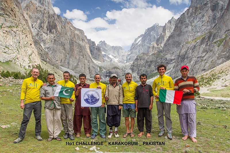
Expedition target and members
While our main goal was to climb summits never so far reached, the other aim of the expedition was to explore the valley and produce a detailed description of the area through photo and video documentation. Our team consisted in Walter Polidori, National Instructor and Expedition Chief; Emanuele Nugara, Regional Instructor; Luca Monfrini and Matteo Filippini, Sectional Instructors, all of them are part of the School. Eventually, Tommaso Lamantia, Alpine Rescue member, took part of the expedition.
Geographical position
The Khane Valley is located in North-East Pakistan, in the Baltistan-Karakorum region (Tagas Group). Perpendicular to the Hushue Valley (which gives access to Masherbrum or K1) and parallel, towards South, to the more popular Nangma Valley, the Khane valley spreads towards East. Still further North of Nangma Valley, the small Khridas Valley and the much more popular Charakusa Valley (thanks to K6 e K7) are located. The Halde Valley is positioned south to the Khane Valley, while a mountain ridge divides the Khane Valley from the Tagas Valley. The Khane village, set at 2800 m (roughly 9200 feet), is the last place reachable by car.
Access
The main entrance to the valley is from Skardu, which is connected to Islamabad by flight (when weather conditions enable to fly) or by a two days drive on the Kakakorum Highway, a very panoramic but yet rather disarranged road.
From Skardu it is possible to get to Khaplu thanks to a gravel road aside the Shyok River; from there, a bridge on the orographic right side of the valley gives access to Hushe Valley along the homonymous river. After driving through Machulo, a small bridge standing at the entrance of the village of Khane can be reached with a five hours drive. Due to the frequency of landslides, the road is often closed to the traffic; we experienced some troubles approaching this area due to the flooding happened at the end of July.
Approaching the Base Camp (First Terrace)
As mentioned, once in the village the valley can only be explored by hiking on a path that develops along a hearty slope on the left orographic side of the valley. This path runs along a characteristic gorge generated by the impetuous Khane River, but in its first part the valley cannot be followed along the river. The path, which is well identified and marked by cairns, enables to reach the slopes on the orographic left side of the river that deeply carves the valley. Along these slopes, a gorgeous path is available with small stony walls containing a water channel. Unfortunately numerous landslides damaged it as well as the path in many spots; in some places it is in fact necessary to cross steep screes.
After a long plane section, the path eventually disappears and it is necessary to cross the river on a temporary bridge simply built using a trunk. From there it is necessary to climb further along a poorly marked path on the orographic right side of the river and then along a more marked trace. The path becomes less and less steep approaching the ruins of a few stone shelters; eventually a large plain (First Terrace, 4000 m, roughly 13 thousand feet) is reached where the base camp is settled (3-4 hours from Khane village).
To be mentioned, the main Khane valley paths and cairns exist thank to the inhabitants of the Khane valley utilizing the First Terrace pastures, rather than by the frequency of the passage of mountaineers or trekkers. In fact, while following these paths, we very frequently encountered many goats and sheep flocks, as well as yak and cattle herds guarded by a local shepherd, named Ismail.
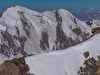
Main valley description
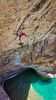
Khane Valley is oriented from West to East. After the First Terrace, towards east, there is a drop where, on the left orographic side, the Khane River ruches within, on the right side a nice waterfall (Waterfall) overcomes a cliff. Roughly located within their middle, the path overcoming this step gives access to the Second Terrace, 4500 m (14800 feet). From there, above a moraine, the glacier, not covered by any snow, appears at the head of the valley.
A little before, a good place for an advanced camp is available, it can be used as starting point for climbs in the upper section of the valley (roughly 4500 m, the Bulgarian base camp was settled here). From this point the valley turns its orientation (South to North) and, after a steep icefall (4900 m), reaches the Khane Col, 5250 m (17200 feet) and gives access to the Nangma Valley.
The detailed description of the most evident mountains impending over the main valley now follows, the sequence starts from base camp towards Khane Col.
Right orographic side:
- Peak46 – this peak has been named Shorsa Tower II by our expedition due to the name used by locals; it is characterized by a graceful and long rocky ridge South-East oriented.
- Peak 41 – the mountain is located south to the massive Sofia Peak and it is characterized, on the East side, by a huge suspended slabs sequence.
- Peak 42 – it is a wide and stocky mountain.
- Peak 35 – this nice mountain is part of a ridge reaching Peak 37.
- Peak 34 – this is probably the first mountain ever climbed in the valley, thanks to the efforts of a Korean team; it is located close to the Waterfall.
- Peak 25 – an American team of mountaineers first attempted to reach this peak; despite they were able to climb a large portion of it, unfortunately they were unable to reach the summit due to poor rock quality.
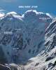
- Agil – impressive mountain with its West wall facing the North Khane Glacier (Second Khane Cwm) and its East wall faced on the main valley above the Ice Fall; its upper slopes are snow covered.
- Peak 23 – it can be reached from the Khane Col II through the Second Khane
Cwm but it is difficult to visually localize. Mixed terrain and snowy portions characterize this mountain.
Left orographic side:
- Peak 226 & 225 – These are little attractive mountains located at the end of debris channels.
- Peak 224 – this is actually a shoulder aside the Grey Tower; the access to it seems to be impervious.
- Grey Tower – this peak was first climbed by the Bulgarian expedition in 2012.
- Peak 223 – this tower divides in two parts the snow channel reaching the Bulgarian Col.
- Peak 68.2 e 68.1., other two towers placed under the north face slopes of Meligo;
- Meligo – impressive and complex mountain, well visible even from the Hushe Valley; a huge serac connects the main summit to the south peak.
- Meligo ridge - it runs through the Fida Tower, Ghulam Tower and then different summits (Saws Ridge) up to Saws Col.
- Spanglab Brakk – this mountain is particularly pretty when seen from the Hushe Valley, with a sharp pyramidal shape.
- The Twins – remarkable mountain shoving a severe mixed wall when observed from the Khane Valley.
- Khamlin – again an impressive mountain.
- Hidden Peak – Huge seracs characterize this mountain.
- Peak 22.2 & 22.1– These peaks are mainly rocky/mixed on the side facing the Khane Valley while snowy on the opposite one.
- Asho Peak II – huge mountain reaching 6000 m (little below 20000 feet) adjacent to the Nangma Valley with a snowy side probably reachable from the Tagas Valley side; the Khane Col is located between Asho Peak and Peak 23.
Secondary valleys and channels
From West to East on the right orographic side of the Valley:
- A debris channel starts from the right side of Shorsa Tower II (Peak 46); from this channel it is possible to reach a col at 4780 m (15700 feet) we named “Hope Col” wishing for an easy climb of Sofia Peak. The col offers the view of a secondary valley orthogonal to the channel (Fifth Khane Cwm) that, starting at a much lower altitude in the Kane Valley, reaches the base of Sofia and Great Tower. Beyond the col, on the left orographic side, it is possible to reach a small terrace at 4800 m (15700 feet) from where a chaotic ridge composed of many difficult to reach rocky towers can be seen. Sofia is located right beyond these towers. Other minor towers are located lower, again on the left orographic side, as well as a channel squeezing among them. The Shorsa Tower II is located on the right side of the channel at its entrance and is connected to the higher Shorsa Tower I (4900 m) by a rocky/grass ridge. Little below the Hope Col, the East ridge reaches the summit of the Shorsa Tower I, which we climbed as first absolute ascent.
- A lateral valley rises toward the Great Tower and Levski Peak (Fourth Khane Cwm). It is located shortly before the Waterfall up to a col, 5270 m (17300 feet), named East Col. On the left orographic side of the valley starting from the bottom, it is possible to spot Peak 35, Peak 37, Rila Peak (forming a stunning ridge), and, eventually, the Lewski Peak, a rocky/snowy summit climbed by the Bulgarian team in 2012.
On the right orographic side, the wide face of Peak 42 is followed by Peak 41, Sofia (with its impressive and complex shape) and the Great Tower (already climbed from the Nangma Valley side).
- Another valley, located between Rila Peak and Tangra Tower (Third Khane Cwm) follows. This is a narrow valley/channel, close to the Waterfall, between the East face of Peak 37 and West face of the Tangra Tower. In its upper part it becomes snowy forming the Tangra Couloir. Right at its beginning, a passage along the left orographic side probably enables to reach a small rocky col from which the East Ridge of the Tangra Tower begins; this is an impressive ridge that presents the evidences of a recent landslip in its lower part.
- Eventually, a last valley develops up to the North Khane Glacier (Second Khane Cwm). It is the first lateral valley on the right orographic side after the Waterfall, a truly gorgeous one! It rises up to a col (Khane Col II) giving access to the Nangma Valley. The peaks from the bottom up on the right orographic side are as follows: Peak 34, Tangra Tower (an amazing granite tower with a beautiful South East wall), North Tangra Peak, South Tower (a rocky mountain presenting a smooth buttress), Central Tower and Thumb Tower (these last three mountains, close to each others, together form an unbelievable scenario) and Trident. Between Trident and Peak 23 lies the Khane Col II; on the left orographic side Peak 25 is followed by Agil and Peak 23.
From West to East on the left orographic side of the Valley the sequence is:
- Channels before the Grey Tower. They are detrital and very steep giving access to secondary towers such as Peak 225 and 226; due to their evident poor rock quality they are fairly unattractive. The first channel on the right of the Grey Tower is likely the key way to reach Peak 224.
- Snowy channel reaching the col between Meligo and Grey Tower (Bulgarian Col, 5107 m). This was used by the Bulgarians to climb the Grey Tower from the col named after them.
- Ramp/channel between The Twins and Meligo. It leads to the Saws Col, a col dividing Peak 64 from Peak 66 at an altitude of 5270 m (17300 feet). We couldn’t find any col or passage easily crossing the mountain chain on the west side to get to the Tagas Valley; from this valley an easy ascent to some summits dividing it from the Khane Valley might be possible following snowy slopes.
Activities carried out by the Italian expedition
Exploring activity (supported by photos, survey of heights and GPS tracking):
1. The main Khane Valley and the Khane glacier has been explored up to the icefall located at 4900 m (16000 feet); unfortunately, the icefall was not practicable due to the very poor ice conditions caused by uncommon high temperatures resulting in frequent ice/stone falls from its lateral slopes.
2. The North Cirque Glacier (Second Khane Cwm), where the Tangra Tower is located, has been explored up to the moraine and the beginning of the upper glacial circus, 5020 m (16500 feet).
3. The valley leading to the Levski Peak (Fourth Khane Cwm), along the bases of Peak 35, Peak 37 and Rila Peak, has been climbed almost up to the col connecting with the Nangme Valley (East Col), 5270 m (17300 feet).
4. The channel rising along the side of Peak 45 and Peak 46, up to the col we named Hope Col (4780 m), has been explored to figure whether from there an attempt to the Sofia was possible.
5. The channel rising behind Peak 42 and two other minor satellites we named The Nails, has been explored.
Mountaineering activity:
1. During the exploration of the channel leading to the Hope Col, Peak 45 has
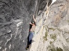
been climbed (the only day with bad weather conditions...) following the East Ridge through what we consider the normal route. This route develops as long as roughly 300 m with mean difficulties of V degree (UIAA); more precisely from III degree up to VI+/VII max. We named this mountain, never climbed before, using its local name Shorsa Tower I. Its height was quoted 4900 m (16100 feet).
The descent consisted by abseiling firstly along the route and then along the South face with independent stances. Even if of good quality, the rock consisted of blocks except for the last pitches where it appeared much more compact.
2. Attempt to Peak 42 along the South face. The rock was apparently attractive with many cracks; however, the presence of dirt, grass and strange concretions into the cracks made climbing very little appealing. Only the first pitch, 35 m long, was climbed with difficulties of VI/A2; an accurate analysis of the following sections, confirming the poor quality on the rock, suggested us to abandon the attempt. The exploration of the lower portions of the other towers led to the same conclusion.
3. Attempt to the col between Twins and Meligo (the Saws Col, m 5270, more precisely located between Peak 64 and Peak 66) to reach the summit of Peak 66, never climbed before. The ascent started from the advanced camp located at 4780 m (15700 feet) before the glacier head. The path consisted of glacial terrain but the ascent stopped roughly midway at 5000 meters due to frequent stone falls from the West face of the Twins, falling rocks accompanied each phase of our attempt.
4. Attempt to Peak 23 from the North Cirque Glacier. The advanced camp, named the Italian High Camp at 5020 meters (16500 feet), was placed before the upper glacial cirque. The climbing consisted of glacial/mixed terrain through the inviolate Khane Col II. Again, we dropped the attempt due to the poor conditions of ice, and terrain in general, on the path to the col. Stones continuously felt from the overhanging face of the Agil throughout the night; furthermore, a snowy and rocky fall missed our camp by only 80 meters the night before.
5. Attempt to a satellite peak near the base camp and located close to Peak 42. Unfortunately, the poor quality of the rock prevented us from reaching its summit by only 30 m; the climbed section was roughly 300 m with difficulties up to III+. The peak (4500 m) was named The Nail I.
Conclusions
Weather conditions have been very favourable throughout the entire time we spent in the valley; however, high temperatures all over the region made it very dangerous, or, rather, impossible to climb on snow/mixed terrain as well as to approach some of the walls attempted. Accordingly, within the same time window much of the attempts to climb the peaks above eight thousands meters located in the area were abandoned due to exceptionally high temperatures. Despite its apparent look, the quality of the rock turned out to be very poor and the large majority of the walls attempted led to the same conclusion ever since their bottom most portions. The frequent rock/snow falls endangered even the climb of mountains with snowy summit or partially covered by snow.
Due to such poor conditions, the majority of our team verified the absence of the minimum safety conditions to climb and therefore, after the exploration phase, we dropped our mountaineering attempts.
Mountaineering history of Khane Valley
The Khane Valley remained unexplored up to only a few years ago for the simple reason that the valleys close to it, such as Nangma and Charakusa, were much more celebrated due to the popularity of their mountains. For this reason the large majority of the mountains in the Kane Valley remain inviolate and unnamed. Only a small number of them, visible from the villages along the Hushe River, from the Nangma Valley or from the high pastures (at roughly 4300 m) along the Khane River, were given a name by local people. According to inhabitants of the Khane village, the first foreigners visiting the valley were from Korea in 2001 and in the two subsequent years. They probably attempted, unsuccessfully, the climb of the West face of Agil. During their second expedition they successfully climbed a 250 m long rocky route on a satellite of a ridge close to their base camp, which was located at 4450 m (14600 feet). After them, an American visitor apparently visited the valley for some trekking after taking part in an expedition to the Ogre Peak. She reached the base of the Great Tower passing through a lateral valley located between the Rila Peak on the east side and the Sofia Peak on the west one.
In 2009 two locals, Ali Mehmed and his son Ruhal Ali, climbed a graceful tower located above the Khane village and called it Nauri Brakk, roughly 3250 m ( 10700 feet). Other ascents were attempted before 2011 from the Nangma Valley: Black Tower (Sarigo), Singu Chapta (named Singu Charpa as well as Great Tower).
As already mentioned a Bulgarian expedition visited the Valley with exploration purposes in September 2011. The Khane valley captured the interest of Doychin Boyanov and Nicolay Petkov, components of the successful 2012 Bulgarian expedition, at first in 2005 and 2006 when they crossed the Valley from North to South descending from the Gondokhoro Pass and then, in 2009, when they returned to the valley after an expedition to Gasherbrun I. In August 2012 they joined the Bulgarian expedition composed by Tervel Kerelov and Michail Michailov, together they successfully ascended, for the first time, the Levski Peak (5520 m) and Grey Tower (5435 m).
From ”Bulgarian Exploratory Expedition Karakoram 2011, N. Petkov on Jan 16, 2012”.
In September 2012 a team composed by Anna Pfaff and Camilo Lopez climbed Peak 25 along the West face up to 200 m from the summit but were then forced to drop the attempt due to the poor quality of the rock.
Acknowledgements
On behalf of the expedition members, I would like to thank all the Instructors of the “Guido della Torre” Mountaineering School and the Presidents of the CAI sections of Busto Arsizio, Castellanza, Legnano, Parabiago and Saronno for their support. My gratitude goes to the city of Castellanza, Legnano and the Banca Popolare di Milano Bank for their funding.
A particular thank goes to Maurizio Pinciroli, the School President who enthusiastically helped us, and to Susanna Martinelli, a School Instructor and a friend, who continuously pushed us towards our objective.
On behalf of Tommaso, a specific thank goes to Salomon and Suunto for their technical support.
Last but not least, I would like to thank my family members for their patience in all these months of work.
by Walter Polidori
Translation from Italian by Vittorio Bedogni, Director of the School Guido della Torre.


 See all photos