Corno Grande, western summit via Calderone glacier - Corno Grande Gran Sasso

 Copia link
 Luca Mazzoleni


 1 / 5
1 / 5 Planetmountain

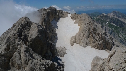
Class outing through into one of the most beautiful areas on the Gran Sasso and the entire Appenines. The Calderone glacier should be ascended in late spring, from the end of May to the start of July, when the ancient glacier still safeguards the winter snow, transformed by now by the sun's rays and therefore easy to ascend with crampons. Until the dangerous snowfields disappear from Passo del Cannone down into the Vallone dei Ginepri void this is certainly the only recommended ascent route from the Teramo flank to the summit. This outing should be avoided in summer when the snow cover deteriorates and the moraine debris - at time comprised of large boulders - rolls down the steep slope, rendering the ascent difficult and dangerous.
Reach l'Aquila, circa 120km NW of Rome.
AccessTake the SS #80 L’Aquila-Teramo road and exit at Ponte Arno. Take the main road to Pietracamela and Prati di Tivo.
ItineraryFrom Prati di Tivo take the new cable car for Madonnina 2028m. If you don't want to take this lift walk up the road which leads off from the car park past the campsite and continues to the col at Cima Alta, also called Laghetto o Balcone but unnamed on the map. At this point the road ascends south, past some alpine meadows and cross a somewhat wider dirt road which leads to a large cross. Ignore this, cross the road, reach the clearly visible Arapietra ridge nearby and follow this to the end. After a short steeper section the path becomes more gentle and leads past the remains of the Diruto Hotel at 1896m (built before the Second World War but never inaugurated). Continue along the wide Arapietra ridge and reach the upper station of the Madonnina cable car (1 hour).
From the end of the lift the route continues along the ridge to the rocky steps beneath Corno Piccolo. The route is obvious and it's difficult to get lost, but avoid the right-hand fork close to a hairpin bend with leads to Ferrata Ventricini and continue upwards to enter into the grandiose Vallone delle Cornacchie via Passo delle Scalette. Vallone delle Cornacchie is shut off on either side by the impending Due Corni rock faces and offers a sweeping view down onto the green Abruzzo hills. The mule track weaves its way past giant boulders transported down to this point by ancient landslides and reaches a point where the old dry stone wall has collapsed and the path narrows: a steel cable has been placed here to help the less expert mountaineers. After the steel cable the path gains height rapidly in the Vallone via a series of tight hairpin bends and after countless switch-backs the first flags appear and, shortly afterwards, Rifugio Franchetti 2433m (1.00 hour from Madonnina).
The path continues above the refuge to beneath the notch located between Corno Grande and Corno Piccolo. Just below this col there is a fork, keep left to reach Corno Grande and the extremely panoramic Sella dei Due Corni 2547m (0.20 from the hut). With your back facing Corno Piccolo continue along the scree ridge (avoid the steep and direct trail on the left and instead follow the easier marked zig-zag path up rightwards) to the base of the rock face. From here continue left, ignoring the fork which leads rightwards to Passo del Cannone, towards Calderone. Upon reaching the first snow patches traverse diagonally to reach the snout and glacial moraine.
(Alternative: if there is too much snow in Vallone delle Cornacchie and on the slopes above the Refuge, ascend directly via the moraine which becomes steeper the higher you get. The ground is often frozen. Past the steepest section you enter the splendid amphitheater locked between the Tre Vette, the three summits.)
After having admired the surroundings and view onto Corno Piccolo ascend the basin on the right, traverse beneath the rocks and ascend the steep narrow section. The basin soon widens out and the angle eases off; reach the summit ridge via a clearly visible col to the right of the summit. Follow the markers used for the Normal route to the summit cross of Corno Grande 2914m (2.30/3.00).
Via the same path: 1.30 for Madonnina; 2.00/2.30 for Prati di Tivo.
GearIce axe, crampons, helmet
Maps/BibliographyRifugio Franchetti - 0861-959634 / 333-2324474.
Luca Mazzoleni has been the hut warden of Rifugio Franchetti since 1988. Furthermore, he has written "La montagna incantata, 204 itinerari di scialpinismo nell’Appennino Centrale" edited by Porzi Editoriali in 2004 and "Guida della’Alta Via scialpinistica dell’Appennino" edited by Porzi Editoriali in 2010.
 Comments