Copia link
 Planetmountain.com


 1 / 3
1 / 3
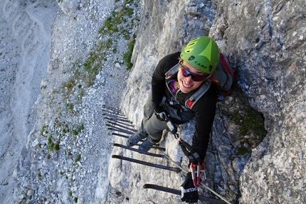
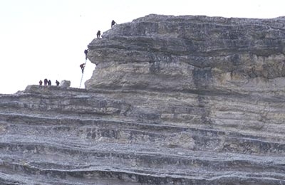
Via Ferrata Ettore Bovero: © Enrico Maioni
 Planetmountain
Beauty


By
Planetmountain.com
Orientation
WSW
Ascent height difference
900m
Ferrata height difference
200m
Height
2160m
Difficulty
Difficult
Time
5 hours
Period
From May to October, owing to its favourable position and low altitude.
Popularity
high
Route
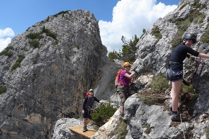
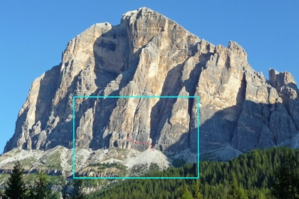
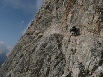
This beautiful, tough ferrata crosses the exposed southwest face of the Col Rosà, the isolated rocky peak between the Tofane and Pomagagnon. Though the vertical climb (completely equipped) is short it gives the expert mountaineer immense satisfaction. On reaching the summit there is an unexpected view onto the valley and the cloister formed by Cortina’s mountains.
Getting there
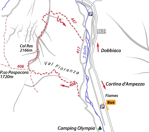
From Cortina head northwards along the Fiames/Podestagno road. Park at Camping Olympia. Access
Skirting Camping Olympia (1290m) first follow the forestry road (no. 417); then take path 408 which follows a steep, winding route through the Val Fiorenza woods towards Passo Pospòrcora (1720m 1 hour 30 min). From here continue right along a steep track through the pine trees up to the start of the ferrata near a cave. Itinerary
From the sign for the ferrata ascend past rocks and pine trees to the steep arête which, looking towards the Boite Valley and Cortina, clearly indicates the line of the ferrata. The cables begin at this point and lead directly to a shoulder (pine trees) and then the summit.
From this start ascend a steep section to then continue on bare rocks in the middle of the arête. Once passed a chimney and a short, exposed traverse, ascend the fun rocky steps that lead to the trees and terrace beneath the summit. With the help of iron rungs climbed quickly up the final wall to, enjoy the fantastic panorama over Cortina. Descent
From the top, follow the long path no. 447 northwards down to the forestry road. This leads back to the car park. Gear
Normal via ferrata kit. Maps/Bibliography
Via Ferratas of the Italian Dolomites: Vol 1 by John Smith and Graham Fletcher. Cicerone Press 2002 Difficulty
Exposed but short itinerary for which a high level of experience is required.

 Comments
20/07/2015 Tobia Breda
Ferrata molto bella, breve e tecnicamente impegnativa. Si arrampica spesso con una forte esposizione (spigolo) su roccia bellissima e ruvida. Come panorama non penso si possa chiedere di meglio con le Tofane alle spalle. Ci sono numerose cenge su cui ci si può sedere ed ammirare il paesaggio. Protezioni nuove e ben mantenute. Parte sommitale di uscita bellissima su gradoni di roccia con staffe. Sentiero di rientro facile e panoramico. Occhio a seguire la traccia giusta che è ben segnalata: ad un certo punto il sentiero sembra andare dritto ma un omino di roccia vi sta segnalando che invece dovete salire la piccola conca scavata dalla natura e andare a destra... Basta non distrarsi e guardarsi attorno ed è francamente difficile sbagliare. Da fare!
31/05/2009 Claudio Sacchi
Un pò noiosa e faticosa la Val Fiorenza fino a Posporcora, poi la ferrata mediamente difficile, con bella vista sul Campanile Rosà, meta preferita da Re Leopoldo del Belgio; meglio non salire vicino ai cavi, gli appigli sono migliori. La discesa è stata rognosa per non aver seguito la via giusta Bye
23/10/2008 Federico Mazzucato
Ferrata molto bella e panoramica! Salita eseguita in una bellissima giornata di sole d'ottobre. E giro concluso con attraversamento a piedi nudi del torrente Boite (all'arrivo a valle)!!! Passaggi molto divertenti e rocciabili nonostante l'esposizione in alcuni tratti. Roccia in generale compatta. Sicuramente da fare!!
22/09/2006 davide
breve faerrata ma interessante perfetta per i primi approcci a queste vie, non presenta difficolta rilevanti piu che difficile la definerei media , sempre che uno non abbi vertigini, perfetta per passarsi una mattinata
Beauty
By
Planetmountain.com
Orientation
WSW
Ascent height difference
900m
Ferrata height difference
200m
Height
2160m
Difficulty
Difficult
Time
5 hours
Period
From May to October, owing to its favourable position and low altitude.
Popularity
high
Route
Routes in the same mountain group