Val Chedul

 Copia link
 Francesco Tremolada, Mountain Guide. Translation by Alexandra Ercolani.


 1 / 3
1 / 3
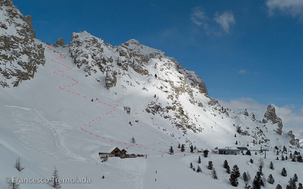
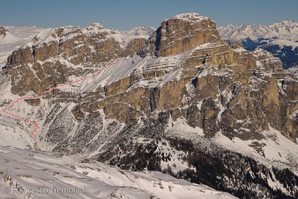
Val Chedul: Photo Francesco Tremolada
 Planetmountain
Beauty


By
Francesco Tremolada, Mountain Guide. Translation by Alexandra Ercolani.
Ascent height difference
250m
Descent height difference
850m
Height
2469m
Difficulty
Easy
Time
1 hour
Ascent exposition
South
Descent exposition
West
Departure
Passo Gardena – Rifugio Jimmy (on old maps it is called rifugio Clark)
Link
Route
A ski mountaineering round trip, easy and frequented both for the beauty of its environment and its views, as well as for its ease of access and return using the lifts.
Access
Reach the area of Passo Gardena by car or using the lifts, head up using the lifts to Rifugio Jimmy at the base of Cir. Itinerary
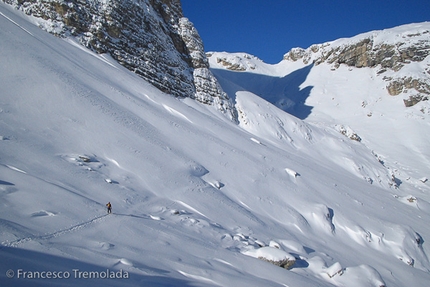
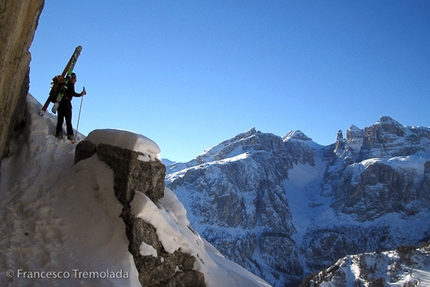
From the hut, with a number of kick turns, climb the snowy slope above till you reach a beautiful area covered in characteristic towers. Overcome a section which is less steep heading to the base of the last steep section which leads to Passo Cir (last metres are usually on foot). Descent
Ski down the centre of the valley along an open slope, with a first section which is quite steep (dangerous with unstable snowpack). Follow the valley to the left overcoming a not very inclined section and a successive slope which is great and leads to the beginning of the vegetation (many descent lines possible). Along the lower section it is worth keeping to the left to turn onto the summer path which goes along the last steep section into the woods to reach Vallunga. From here turn onto the cross country ski slope which you follow to the left until you reach the chair lift at the end of the valley. With this you join up with the Sellaronda lifts. Gear
Normal ski mountaineering equipment, Notes
This itinerary is ideal for those just starting ski mountaineering.
Other options: The southern side of Cir offers a number of couloirs which are ideal training ground for steep skiing. To lengthen the itinerary, once you reach Passo Cir, you can descend to the right (on skis) and continue the ascent reaching Forcella Crespeina and the top of Col Toronn. Maps/Bibliography
Maps: Tabacco 1:25.000 foglio 7 Alta Badia
Guidebook: Francesco Tremolada, “Freeride in Dolomiti”, ed. Versante Sud
Alta Badia Tourist Office: www.altabadia.org
Alta Badia mountain guides, Corvara: www.altabadiaguides.com
Reach the area of Passo Gardena by car or using the lifts, head up using the lifts to Rifugio Jimmy at the base of Cir. Itinerary
From the hut, with a number of kick turns, climb the snowy slope above till you reach a beautiful area covered in characteristic towers. Overcome a section which is less steep heading to the base of the last steep section which leads to Passo Cir (last metres are usually on foot). Descent
Ski down the centre of the valley along an open slope, with a first section which is quite steep (dangerous with unstable snowpack). Follow the valley to the left overcoming a not very inclined section and a successive slope which is great and leads to the beginning of the vegetation (many descent lines possible). Along the lower section it is worth keeping to the left to turn onto the summer path which goes along the last steep section into the woods to reach Vallunga. From here turn onto the cross country ski slope which you follow to the left until you reach the chair lift at the end of the valley. With this you join up with the Sellaronda lifts. Gear
Normal ski mountaineering equipment, Notes
This itinerary is ideal for those just starting ski mountaineering.
Other options: The southern side of Cir offers a number of couloirs which are ideal training ground for steep skiing. To lengthen the itinerary, once you reach Passo Cir, you can descend to the right (on skis) and continue the ascent reaching Forcella Crespeina and the top of Col Toronn. Maps/Bibliography
Maps: Tabacco 1:25.000 foglio 7 Alta Badia
Guidebook: Francesco Tremolada, “Freeride in Dolomiti”, ed. Versante Sud
Alta Badia Tourist Office: www.altabadia.org
Alta Badia mountain guides, Corvara: www.altabadiaguides.com
 Comments
No comments yet...
Beauty
By
Francesco Tremolada, Mountain Guide. Translation by Alexandra Ercolani.
Ascent height difference
250m
Descent height difference
850m
Height
2469m
Difficulty
Easy
Time
1 hour
Ascent exposition
South
Descent exposition
West
Departure
Passo Gardena – Rifugio Jimmy (on old maps it is called rifugio Clark)
Link
Route
Routes in the same mountain group
Related news
31/12/2010 - Snow Ski-skimountaineering
Freeride skiing in the Alta Badia, Dolomites A brief introduction to seven freeride itineraries in Alta Badia, Dolomites, by Mountain Guide Francesco Tremolada.