Cresta Croce - Cresta Croce

 Copia link
 Cain Olsen, Adamello Mountain Guides


 1 / 2
1 / 2
Cresta Croce
 Planetmountain
Beauty


By
Cain Olsen, Adamello Mountain Guides
Orientation
South
Ascent height difference
900 metres approx.
Descent height difference
350 metres approx.
Height
3276m
Difficulty
F
Time
6 hours
Period
From June - September
Popularity
Medium
Departure
Rifugio Città di Trento
Arrival
Rifugio Caduti dell’Adamello
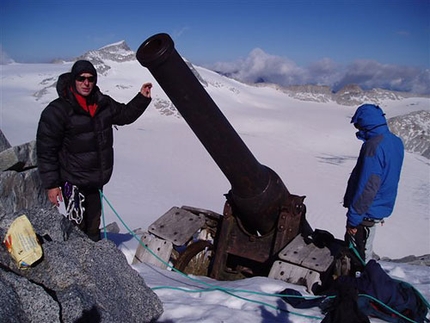
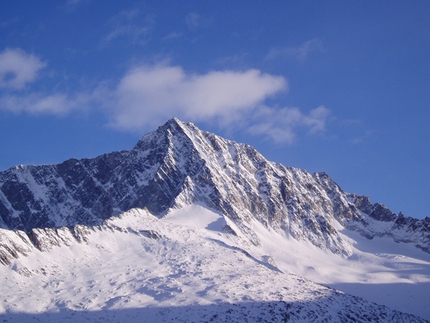
Dragging a 6000kg 149/G cannon from Temù, located at circa 1000m altitude, to Cresta Croce above 3000m: this was an undertaking which had never been achieved previously. Few thought that this task was feasible, but in 1916 the Italian troops managed the impossible. This easy outing at altitude follows a spectacular ridge which offers breathtaking 360° views onto Presanella, Adamello and the Brenta group to reach this cannon, nicknamed the Hippopotamus, and the summit of Cresta Croce at 3276m.
Getting there
Reach Passo Tonale. Access
Start from the Rifugio Città di Trento Itinerary
Rifugio Città di Trento - Rifugio Caduti dell’Adamello
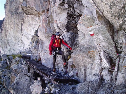
After breakfast, head towards the Vedretta del Mandrone, part of the Pian di Neve glacier, the largest in the Italian Alps. The scenery is unique: a desert made of ice, crevasses, icefalls, streams, peaks and ridges surround us for kilometres and kilometres.
Continue up hill on the icy terrain towards the Caduti all’Adamello hut (3040 metres) from where one can admire a 360° view of the Adamello mountains. Leave some of our equipment at the hut for the night, and after some refurbishment, head to Cresta Croce (3276 metres) where one can visit the Cannon 149G that was positioned here by the Italians during the First World War. Return to the recently renovated hut in time to enjoy a beer while watching the sun set over the ice field. Gear
Backpack (40 litres), harness, crampons, rigid sole mountaineering boots, sleeping sheet, thermos for hot drinks, energy bars and dried fruit, first aid, glacier sun glasses (cat. 4), goretex jacket and trousers, gloves and hat, sun protection, torch, camera, map, pocket knife. Maps/Bibliography
Guida dei Monti d’Italia CAI – Touring Club, Adamello volume I e II, Pericle Sacchi
Nordpress, Adamello Vol.1, Piermario Soregaroli
Map Kompass Adamello 1:25000
www.museoguerrabianca.it
www.parcoadamello.it
www.adamelloski.com
www.guidealpineadamello.it
Reach Passo Tonale. Access
Start from the Rifugio Città di Trento Itinerary
Rifugio Città di Trento - Rifugio Caduti dell’Adamello
After breakfast, head towards the Vedretta del Mandrone, part of the Pian di Neve glacier, the largest in the Italian Alps. The scenery is unique: a desert made of ice, crevasses, icefalls, streams, peaks and ridges surround us for kilometres and kilometres.
Continue up hill on the icy terrain towards the Caduti all’Adamello hut (3040 metres) from where one can admire a 360° view of the Adamello mountains. Leave some of our equipment at the hut for the night, and after some refurbishment, head to Cresta Croce (3276 metres) where one can visit the Cannon 149G that was positioned here by the Italians during the First World War. Return to the recently renovated hut in time to enjoy a beer while watching the sun set over the ice field. Gear
Backpack (40 litres), harness, crampons, rigid sole mountaineering boots, sleeping sheet, thermos for hot drinks, energy bars and dried fruit, first aid, glacier sun glasses (cat. 4), goretex jacket and trousers, gloves and hat, sun protection, torch, camera, map, pocket knife. Maps/Bibliography
Guida dei Monti d’Italia CAI – Touring Club, Adamello volume I e II, Pericle Sacchi
Nordpress, Adamello Vol.1, Piermario Soregaroli
Map Kompass Adamello 1:25000
www.museoguerrabianca.it
www.parcoadamello.it
www.adamelloski.com
www.guidealpineadamello.it
 Comments
No comments yet...
Beauty
By
Cain Olsen, Adamello Mountain Guides
Orientation
South
Ascent height difference
900 metres approx.
Descent height difference
350 metres approx.
Height
3276m
Difficulty
F
Time
6 hours
Period
From June - September
Popularity
Medium
Departure
Rifugio Città di Trento
Arrival
Rifugio Caduti dell’Adamello
Routes in the same mountain group

Related news
27/08/2007 - Alpinism
Hiking on Italy’s largest glacier: Pian di Neve, Adamello A magnificent four day outing in the Adamello massif to discover First World War history, geology and glaciology, local culture, traditions, flora and fauna.