Adamello Haute Route, Trail Number 1

 Copia link
 Jimmy Sabbadin


 1 / 24
Adamello Haute Route, Trail Number 1
 Planetmountain
Beauty

By
Jimmy Sabbadin
Length
70km
Height
2000m - 3000m
Difficulty
Expert hikers
Time
5 - 8 days
Departure
Conca di Bazena, Valle Camonica
Arrival
Preda, Valle Camonica
The Alta Via dell'Adamello is journey into Italy's past, via the remains and signs of the White War which, for four years, witnessed Italians and Austrians battle against each other at over 3000m altitude in unimaginable conditions during the First World War.
The path No.1 crosses the Adamello Park in the heart of the Rhaetian Alps, home to a wealth of different ecosystems, determined by the great altitude differences (from 400 to 3554 metres above sea level), the geological complexity of the area and the distinctiveness of each valley.
The Adamello Trek is circa 70km long and is split into 5/8 sections and connects numerous mountain huts along the way, starting from the Bazena close to the Crocedomini pass, via Adamello's impressive north face, and finishing at the mountains close to Edolo. The trek crosses the Adamello mountain range from south to north at an altitude of 2000 - 3000m, with numerous mountain passes above 2700m which are often covered in snow.
Although the walk is generally fairly easy, there are some short exposed and difficult sections. These have been equipped with a series of steel cables and steps, but remain delicate especially in difficult conditions (verglas, ice, snow, rain). The path peters out on the most isolated sections of the trek but the obvious red and white markers show the way.
The Adamello Trail Number 1 is suitable for medium, fit hikers with the right equipment, proper knowledge of the area and the right gear to navigate in a mountain environment.
Getting there
The Alta Via dell’Adamello is best reached via Conca di Bazena in Valle Camonica close to the Crocedomini pass. This is reached by taking the A4 Milano-Venezia motorway, exiting at Brescia centro and continuing on towards alle Camonica - Passo del Tonale. Exit for Breno Nord, from Breno head towards Passo Crocedomini. Bazena is located 1 km before the pass. Itinerary
Stage 1: From rifugio Tassara in the Bazena basin to Rifugio Tita Secchi located at Lago della Vacca
The first stretch of the Trek goes through the most interesting areas in the Park for flowers. From mid June to the end of July, the rare endemic species typical of this area can be admired in all their glory. The path crosses the “Val Fredda botanical route”, which gives us a chance to see local wild flowers, with the help of numerous dedicated information boards. This stretch of the trail also crosses the huge Crocedomini pastures, well-known for their flourishing animal farms in the Summer, famous for the breading of milk cows and the goodness of the cheeses produced here. From June to October, you can still come a across herds of cows, find the herdsmen shelters occupied by farmers and buy some Silter cheese produced here.
Time: 2:30 hours
Uphill: 580m
Downhill: 50m
Stage 2: From Rifugio Tita Secchi to Rifugio Maria e Franco at the Derna pass
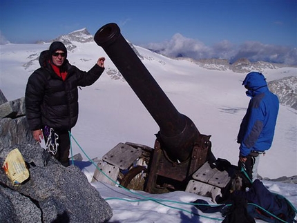
A historically interesting stage past valuable relics from the Guerra Bianca (White War, the name given to the First World War that was fought here): artillery posts, caves used as shelters and the remains of barracks where soldiers camped. This stage is one of the wildest and most isolated sections along the entire trek.
Time: 5:30 hours
Uphill: 700
Downhill: 500
Stage 3: From rifugio Maria e Franco to Rifugio Città di Lissone in Valle Adamè and Rifugio Baita Adamè
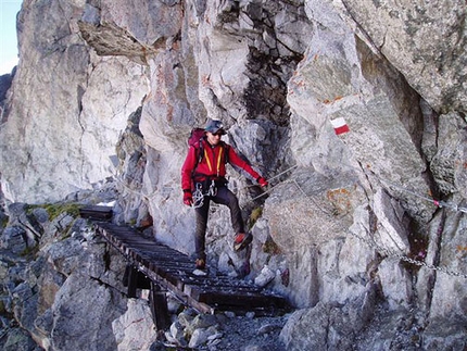
This is a technical stage as the Ignaga ridge is the most exposed and hardest section along the entire trek. Recently it has been equipped with wire cables and steps. The view onto the Adamello glacier from here is spectacular and as you continue to the hut you walk past numerous First World War remains which testament the hardship of the war at over 3000m.
Time: 5 hours
Uphill: 300m
Downhill: 800m
Stage 4: From Rifugio Città di Lissone to Rifugio Prudenzini in Val Salarno
Highly interesting stage from a geological perspective. The wonderful Valle Adamè is a textbook example of a typical U-shaped valley, smoothed over thousands of years by the glacierduring the last ice age. The enchanting Adamè River has cut its way deep into the valley bed and springs from the alpine meadows at altitude. Malga Adamè is located in the middle of the valley and this shelter is still used by herdsmen who bring their goats here for summer grazing. The "Bionda dell’Adamello" is bred nativally and has a hazelnut coloured coat that turns blonde (bionda) in the summer sun. The milk produced by this breed is used to make "Fatulì", a prize-winning goats’ cheese smoked over juniper branches. The ascent to to the Poia Pass shouldn't be underestimated due to its lenght and altitude gain.
Time: 4h:45 hours
Uphill: 770m
Downhill: 520m
Stage 5: From Rifugio Prudenzini at Conca del Miller and Baitone and the mountain huts Gnutti, Baitone, Tonolini
An interesting stage for its fauna, the ridges of the Salarno and Miller Valleys and the perfect habitat for the rare Snow Grouse, a mimetic Tetranoid that lives and nests in this harsh environment. The Baitone Valley is without doubt the best place to spot Chamois Deer and Ibex. The later has become one of the symbols of the Park’s activities following the reintroduction project that started in 1995, which has allowed the return of this royal bovid to an area where it had become extinct in 1700. Care is required when crossing the Miller Pass.
Time: 5:30 hours
Up hill: 960m
Down hill: 715m
Stage 6: From Conca del Miller e Baitone to Rifugio Garibaldi in Val d’Avio
An interesting stage from an anthropical point of view, Val d’Avio is noteworthy for its impressive hydroelectric reservoirs, the industrial archaeology and, above all, the majestic north and west faces of Monte Adamello which plunge 700m down into the Avio and Venerocolo glaciers. At 3554 metres above sea level, the peak juts out of the Adamello Glacier (also known as Pian di Neve), the biggest in Italy and the only one in the Alps to feature the typical Scandinavian plateau glacial configuration. Care is needed when descending from the Premessone pass.
Time: 5h
Uphill: 750m
Downhill: 650m
Stage 7: From Rifugio Garibaldi to Rifugio Sandro Occhi at Lago dell’Aviolo
The Aviolo basin is a little jewel in the Adamello Park: Lake Aviolo with its surrounding plateaus is one of the most beautiful in the entire Alps. Peat bogs rich with endemic species, suspended glaciers, and geological faults abound, as do chamois on the steep slopes since the herds continue to grow in number. Thanks to the particular geology and the diverse rock types on the ascent up to Passo Gallinera, rare endemic flowers bloom in July including the carniverous Drosera angelica.
Time: 6:15 hours
Uphill: 860m
Downhill: 1470m
Stage 8: From Rifugio Sandro Occhi to Rifugio Malga Stain
An interesting stage that crosses isolated Val Gallinera marked by wild fauna, brown bear and golden eagle. This valley, along with Val Rabbia, form part of the natural reserve established to protect and conserve a hitherto untouched natural habitat. The section which leads from Malga Stain to Mone Colmo at the end of the Haute Route #1 crosses fabulous century-old larch and red pine forests and splendid sunny meadows, home to Greek partridge and the golden eagle.
Time: 4 hours
Uphill: 590m
Downhill: 730m Gear
30 litre rucksack, walking trousers, breathable shirt, fleece or down jacket, waterproofs, gloves, hat, headtorch, suntan lotion, map, compass/GPS, thermos. Highly recommended: crampons and ice axe. Snow may still be found well into late spring. Notes
Rif. C. Tassara, Bazena 1800m
Vittorio Gelmini - Tel. +39 0364 310777 - Mobile +39 335 6008693 Open all year
How to get there: road to Passo Crocedomini (Bs), from Breno (18km) or Bagolino (20km), loc. Bazena.
Rif. Tita Secchi, Lago della Vacca 2367m
Giacomo Baccanelli - Tel. +39 0365 903001 - Mobile +39 337 441650. Open 1/6 – 20/10, New Year on demand
How to get there: 1: from Bagolino, loc. Piana Gaver, path #17 - 2:15 hours +1000mt. 2: from Bagolino, loc. Malga Cadino, path#19 - 2hours +700mt. 3: from Breno, loc. Bazena, path#18 - 2:15 hours +600m
Rif. Maria e Franco, Passo Dernal 2574m
Giacomo Masussi - Tel. +39 0364 634372. Open 15/6 - 15/9
How to get there: from Casere di Val Paghera di Ceto, via Val Dois, path#37 - 4:45 hours +1358m
Rif. Lissone, Val Adamè 2020m
Domenico Ferri - Tel. +39 0364 638296 - Mobile +39 347 1578024. Open 1/6 - 30/09
How to get there: from Val Saviore, loc. Malga Lincino 1621m - path #15 - 1 hour +400m
Rif. Baita Adamè, Val Adamè 2150m
How to get there: as for Rifugio Lissone.
Rif. Prudenzini, Val Salarno 2235m
C.A.I. Brescia - Tel. +39 0364 634578. Open 15/6 - 15/9
How to get there: from Val Salarno di Saviore dell’Adamello, loc. Fabrezza 1458m - path#14 - 2:30 hours +767m
Rif. Gnutti, Val Miller 2166m
Domenica Madeo Fiorani - Tel. +39 0364 72241 - Tel. gestore +39 030 2751226. Open 15/6 - 15/9
How to get there: from Val Malga di Sonico, loc. Malga Premassone 1550m - path #23 - 2 hours +616m
Rif. Baitone, Lago Baitone 2281m
Stefano Cattaneo - Tel. +39 0364 902943 - Mobile +39 393 3948627. Open 15/6 - 15/9
How to get there: dalla from Malga di Sonico, loc. Malga Premassone 1550m - path #13 - 2:15 hours’ +731mt
Rif. Tonolini, Conca del Baitone 2450m
Fabio Madeo - Tel. +39 0364 71181 - Mobile +39 338 9282075 Open 15/6 - 15/9
How to get there: from Val Malga di Sonico, loc. Malga Premassone 1550m - path #13 - 2:45 hours +900m
Rif Garibaldi, Lago Venerocolo 2550m
Odoardo Ravizza, Tel. +39 0364 906209 - Mobile +39 339 5236327. Open 15/6 - 15/9, in spring on demand
How to get there: from Val d’Avio di Temù, loc. Malga Caldea 1584m - road for Laghi d’Avio, then path #1 - 3:30 hours +966m
Rif. Sandro Occhi, Lago Aviolo 1930m
Giacomo Vidilini, Tel. +39 0364 76110 - Tel. gestore +39 0364 72863. Open 01/6 - 30/9
How to get there: from Val Paghera di Vezza d’Oglio, loc. Rif. Alla Cascata 1453m - path#21 - 1:20 hours +477m
Rif. Malga Stain, Belvedere Edolo 1832m
Federico Savardi, Tel. +39 338 8542450 - Mobile +39 338 8542450, Open: June - Spetember
How to get there: from Edolo take the road for Monte Colmo, loc. Preda 1502 - path #21 - 45 minutes +280m
The Alta Via dell’Adamello is best reached via Conca di Bazena in Valle Camonica close to the Crocedomini pass. This is reached by taking the A4 Milano-Venezia motorway, exiting at Brescia centro and continuing on towards alle Camonica - Passo del Tonale. Exit for Breno Nord, from Breno head towards Passo Crocedomini. Bazena is located 1 km before the pass. Itinerary
Stage 1: From rifugio Tassara in the Bazena basin to Rifugio Tita Secchi located at Lago della Vacca
The first stretch of the Trek goes through the most interesting areas in the Park for flowers. From mid June to the end of July, the rare endemic species typical of this area can be admired in all their glory. The path crosses the “Val Fredda botanical route”, which gives us a chance to see local wild flowers, with the help of numerous dedicated information boards. This stretch of the trail also crosses the huge Crocedomini pastures, well-known for their flourishing animal farms in the Summer, famous for the breading of milk cows and the goodness of the cheeses produced here. From June to October, you can still come a across herds of cows, find the herdsmen shelters occupied by farmers and buy some Silter cheese produced here.
Time: 2:30 hours
Uphill: 580m
Downhill: 50m
Stage 2: From Rifugio Tita Secchi to Rifugio Maria e Franco at the Derna pass
A historically interesting stage past valuable relics from the Guerra Bianca (White War, the name given to the First World War that was fought here): artillery posts, caves used as shelters and the remains of barracks where soldiers camped. This stage is one of the wildest and most isolated sections along the entire trek.
Time: 5:30 hours
Uphill: 700
Downhill: 500
Stage 3: From rifugio Maria e Franco to Rifugio Città di Lissone in Valle Adamè and Rifugio Baita Adamè
This is a technical stage as the Ignaga ridge is the most exposed and hardest section along the entire trek. Recently it has been equipped with wire cables and steps. The view onto the Adamello glacier from here is spectacular and as you continue to the hut you walk past numerous First World War remains which testament the hardship of the war at over 3000m.
Time: 5 hours
Uphill: 300m
Downhill: 800m
Stage 4: From Rifugio Città di Lissone to Rifugio Prudenzini in Val Salarno
Highly interesting stage from a geological perspective. The wonderful Valle Adamè is a textbook example of a typical U-shaped valley, smoothed over thousands of years by the glacierduring the last ice age. The enchanting Adamè River has cut its way deep into the valley bed and springs from the alpine meadows at altitude. Malga Adamè is located in the middle of the valley and this shelter is still used by herdsmen who bring their goats here for summer grazing. The "Bionda dell’Adamello" is bred nativally and has a hazelnut coloured coat that turns blonde (bionda) in the summer sun. The milk produced by this breed is used to make "Fatulì", a prize-winning goats’ cheese smoked over juniper branches. The ascent to to the Poia Pass shouldn't be underestimated due to its lenght and altitude gain.
Time: 4h:45 hours
Uphill: 770m
Downhill: 520m
Stage 5: From Rifugio Prudenzini at Conca del Miller and Baitone and the mountain huts Gnutti, Baitone, Tonolini
An interesting stage for its fauna, the ridges of the Salarno and Miller Valleys and the perfect habitat for the rare Snow Grouse, a mimetic Tetranoid that lives and nests in this harsh environment. The Baitone Valley is without doubt the best place to spot Chamois Deer and Ibex. The later has become one of the symbols of the Park’s activities following the reintroduction project that started in 1995, which has allowed the return of this royal bovid to an area where it had become extinct in 1700. Care is required when crossing the Miller Pass.
Time: 5:30 hours
Up hill: 960m
Down hill: 715m
Stage 6: From Conca del Miller e Baitone to Rifugio Garibaldi in Val d’Avio
An interesting stage from an anthropical point of view, Val d’Avio is noteworthy for its impressive hydroelectric reservoirs, the industrial archaeology and, above all, the majestic north and west faces of Monte Adamello which plunge 700m down into the Avio and Venerocolo glaciers. At 3554 metres above sea level, the peak juts out of the Adamello Glacier (also known as Pian di Neve), the biggest in Italy and the only one in the Alps to feature the typical Scandinavian plateau glacial configuration. Care is needed when descending from the Premessone pass.
Time: 5h
Uphill: 750m
Downhill: 650m
Stage 7: From Rifugio Garibaldi to Rifugio Sandro Occhi at Lago dell’Aviolo
The Aviolo basin is a little jewel in the Adamello Park: Lake Aviolo with its surrounding plateaus is one of the most beautiful in the entire Alps. Peat bogs rich with endemic species, suspended glaciers, and geological faults abound, as do chamois on the steep slopes since the herds continue to grow in number. Thanks to the particular geology and the diverse rock types on the ascent up to Passo Gallinera, rare endemic flowers bloom in July including the carniverous Drosera angelica.
Time: 6:15 hours
Uphill: 860m
Downhill: 1470m
Stage 8: From Rifugio Sandro Occhi to Rifugio Malga Stain
An interesting stage that crosses isolated Val Gallinera marked by wild fauna, brown bear and golden eagle. This valley, along with Val Rabbia, form part of the natural reserve established to protect and conserve a hitherto untouched natural habitat. The section which leads from Malga Stain to Mone Colmo at the end of the Haute Route #1 crosses fabulous century-old larch and red pine forests and splendid sunny meadows, home to Greek partridge and the golden eagle.
Time: 4 hours
Uphill: 590m
Downhill: 730m Gear
30 litre rucksack, walking trousers, breathable shirt, fleece or down jacket, waterproofs, gloves, hat, headtorch, suntan lotion, map, compass/GPS, thermos. Highly recommended: crampons and ice axe. Snow may still be found well into late spring. Notes
Rif. C. Tassara, Bazena 1800m
Vittorio Gelmini - Tel. +39 0364 310777 - Mobile +39 335 6008693 Open all year
How to get there: road to Passo Crocedomini (Bs), from Breno (18km) or Bagolino (20km), loc. Bazena.
Rif. Tita Secchi, Lago della Vacca 2367m
Giacomo Baccanelli - Tel. +39 0365 903001 - Mobile +39 337 441650. Open 1/6 – 20/10, New Year on demand
How to get there: 1: from Bagolino, loc. Piana Gaver, path #17 - 2:15 hours +1000mt. 2: from Bagolino, loc. Malga Cadino, path#19 - 2hours +700mt. 3: from Breno, loc. Bazena, path#18 - 2:15 hours +600m
Rif. Maria e Franco, Passo Dernal 2574m
Giacomo Masussi - Tel. +39 0364 634372. Open 15/6 - 15/9
How to get there: from Casere di Val Paghera di Ceto, via Val Dois, path#37 - 4:45 hours +1358m
Rif. Lissone, Val Adamè 2020m
Domenico Ferri - Tel. +39 0364 638296 - Mobile +39 347 1578024. Open 1/6 - 30/09
How to get there: from Val Saviore, loc. Malga Lincino 1621m - path #15 - 1 hour +400m
Rif. Baita Adamè, Val Adamè 2150m
How to get there: as for Rifugio Lissone.
Rif. Prudenzini, Val Salarno 2235m
C.A.I. Brescia - Tel. +39 0364 634578. Open 15/6 - 15/9
How to get there: from Val Salarno di Saviore dell’Adamello, loc. Fabrezza 1458m - path#14 - 2:30 hours +767m
Rif. Gnutti, Val Miller 2166m
Domenica Madeo Fiorani - Tel. +39 0364 72241 - Tel. gestore +39 030 2751226. Open 15/6 - 15/9
How to get there: from Val Malga di Sonico, loc. Malga Premassone 1550m - path #23 - 2 hours +616m
Rif. Baitone, Lago Baitone 2281m
Stefano Cattaneo - Tel. +39 0364 902943 - Mobile +39 393 3948627. Open 15/6 - 15/9
How to get there: dalla from Malga di Sonico, loc. Malga Premassone 1550m - path #13 - 2:15 hours’ +731mt
Rif. Tonolini, Conca del Baitone 2450m
Fabio Madeo - Tel. +39 0364 71181 - Mobile +39 338 9282075 Open 15/6 - 15/9
How to get there: from Val Malga di Sonico, loc. Malga Premassone 1550m - path #13 - 2:45 hours +900m
Rif Garibaldi, Lago Venerocolo 2550m
Odoardo Ravizza, Tel. +39 0364 906209 - Mobile +39 339 5236327. Open 15/6 - 15/9, in spring on demand
How to get there: from Val d’Avio di Temù, loc. Malga Caldea 1584m - road for Laghi d’Avio, then path #1 - 3:30 hours +966m
Rif. Sandro Occhi, Lago Aviolo 1930m
Giacomo Vidilini, Tel. +39 0364 76110 - Tel. gestore +39 0364 72863. Open 01/6 - 30/9
How to get there: from Val Paghera di Vezza d’Oglio, loc. Rif. Alla Cascata 1453m - path#21 - 1:20 hours +477m
Rif. Malga Stain, Belvedere Edolo 1832m
Federico Savardi, Tel. +39 338 8542450 - Mobile +39 338 8542450, Open: June - Spetember
How to get there: from Edolo take the road for Monte Colmo, loc. Preda 1502 - path #21 - 45 minutes +280m


 See all photos
 Comments
16/07/2012 Enrico Bestetti
Bellissimo trekk in ambienti selvaggi.
Lo abbiamo fatto nel 2009 e siamp tornati con 2000 foto, le trovate a questo indirizzo:
http://adamello.altervista.org/adamello_sito/html/index.htm
06/05/2011 Matteo Rizzardi
Il percorso del sentiero è affascinante e permette di ammirare panorami splendidi. Per chi abita non troppo distante è molto bello anche farne delle tappe in giornata. Molto esauriente la relazione che finalmente valorizza dei luoghi magnifici ricchi si storia e ricchezze naturali. Buona passeggiata a tutti!
Beauty
By
Jimmy Sabbadin
Length
70km
Height
2000m - 3000m
Difficulty
Expert hikers
Time
5 - 8 days
Departure
Conca di Bazena, Valle Camonica
Arrival
Preda, Valle Camonica
Routes in the same mountain group