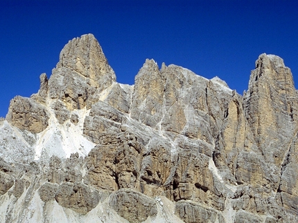
Tru Dolomieu - Cima Cunturines

 Copia link
 Planetmountain.com


 1 / 3
1 / 3
Tru Dolomieu
 Planetmountain
Beauty


By
Planetmountain.com
Orientation
South
Ascent height difference
1340m
Ferrata height difference
100m
Height
3064m
Difficulty
Easy
Time
8 hours
Period
From July to September, depending on snow conditions.
Popularity
medium
Route
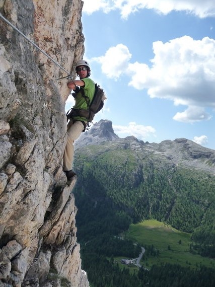
The long approach, the wild environment and uncontaminated surroundings make this outing an ideal choice for those in search of silence and the magical, hidden secrets of the Dolomites. A short Via Ferrate, dedicated to the discoverer of the “magic” dolomia Déodat de Dolomieu, leads to the summit of the isolated Piz Cunturines which, together with Lavarella, looks down onto the green Valle di San Cassiano. Looking eastwards one is rewarded with unhindered views as far as the snow covered Ortles.
Getting there
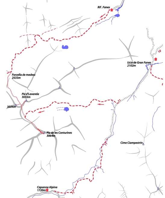
1) From Passo Falzarego or S. Cassiano take the Passo di Valparola road and turn off (north) at the Ru Sciare bridge to reach Capanna Alpina all’Armentarola (1726m).
2) From S. Vigilio di Marebbe drive to Rifugio Pederù. Access
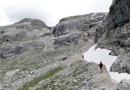
1) From Capanna Alpina take path no. 11 and cross Plan de Furcia to swiftly climb up to Col de Lòcia (2069m). Continue to Passo Tadega (2157m), where the path forks left (west) to lead up Vallon di Lavares towards Cunturines and Lavarella. The path crosses scree slopes past the Cunturines lake to Piz delle Due Forcelle (2929m).
2) From Rif. Pederù walk to Rif Fanes (2060m) and proceed to Alpe di Fanes Grande (2 hrs) and Passo Tadega (2157m). Continue from here as described above. Itinerary
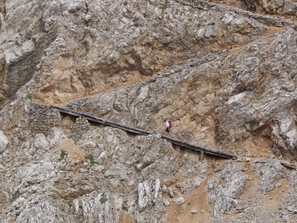
Reach the northernmost col between Cunturines and Lavarella and follow the line of ascent left up scree (and not right towards Lavarella) to a wooden ladder that marks the start of the Ferrata. After this short vertical section continue right along an equipped ledge to reach easier ground. More cables lead past stepped terrain to a wooden bridge and on the final scramble to the summit. Descent
As for the ascent Gear
Normal via ferrata kit. Maps/Bibliography
Via Ferratas of the Italian Dolomites: Vol 1 by John Smith and Graham Fletcher . Cicerone Press 2002 Difficulty
The brief Via Ferrata, although not particularly difficult, requires a certain degree of physical fitness due to its long and tiring approach. Some sections are not equipped and although an easy scramble, friable in places.
1) From Passo Falzarego or S. Cassiano take the Passo di Valparola road and turn off (north) at the Ru Sciare bridge to reach Capanna Alpina all’Armentarola (1726m).
2) From S. Vigilio di Marebbe drive to Rifugio Pederù. Access
1) From Capanna Alpina take path no. 11 and cross Plan de Furcia to swiftly climb up to Col de Lòcia (2069m). Continue to Passo Tadega (2157m), where the path forks left (west) to lead up Vallon di Lavares towards Cunturines and Lavarella. The path crosses scree slopes past the Cunturines lake to Piz delle Due Forcelle (2929m).
2) From Rif. Pederù walk to Rif Fanes (2060m) and proceed to Alpe di Fanes Grande (2 hrs) and Passo Tadega (2157m). Continue from here as described above. Itinerary
Reach the northernmost col between Cunturines and Lavarella and follow the line of ascent left up scree (and not right towards Lavarella) to a wooden ladder that marks the start of the Ferrata. After this short vertical section continue right along an equipped ledge to reach easier ground. More cables lead past stepped terrain to a wooden bridge and on the final scramble to the summit. Descent
As for the ascent Gear
Normal via ferrata kit. Maps/Bibliography
Via Ferratas of the Italian Dolomites: Vol 1 by John Smith and Graham Fletcher . Cicerone Press 2002 Difficulty
The brief Via Ferrata, although not particularly difficult, requires a certain degree of physical fitness due to its long and tiring approach. Some sections are not equipped and although an easy scramble, friable in places.

 Comments
14/08/2008 carlo giorgioni
La mia prima ferrata in assoluto!In realtà si tratta del culmine attrezzato (20 min) di un'escursione ben più lunga che in 10 ore ti fa partire e tornare dall'Armentarola.Da alcuni punti molto esposti della breve ferrata si può vedere (tra i propri piedi) la propria macchina parcheggiata 1.300 m più in basso!
08/02/2003 info
Lunga escursione culminante con una breve ferrata su sentiero di guerra e con una breve cresta. Il vallone di salita è solitario, arcaico e maestoso. Stupendo il panorama dai 3.000 mt del Piz.
08/10/2002 Spalla Massimo
E' una salita molto bella (ed anche lunga e faticosa) ad una montagna splendida. Poco affollata (quando l'ho fatta io, ho incontrato solo altre 2 persone) specie dopo il lago Cunturines. La ferrata e' molto breve e non difficile. All'epoca c'erano delle "curiose" scale di legno, che non mi rassicuravano piu' di tanto. Alla fine delle difficolta' c'e' una crestina (per niente difficile) un po' esposta: fare attenzione. In conclusione giro bello ma MOLTO lungo (dislivello e' di circa 1300 mt e lo sviluppo e' di parecchi Kilometri)
30/03/2002 Ernesto Majoni
Intanto, la foto di presentazione ritrae il Piz Taibon e non il Piz Cunturines!!! Non si può parlare di ferrata, ma di una via no9rmale ad un grande 3000 dolomitico, lunga e faticosa ma nel complesso non difficile. Chi ama le grandi cime, non dovrebbe lasciarsela sfuggire. Il tratto di ferrata è breve, facile e ben attrezzato, ma siamo pur sempre tra i 2900 e i 3050 metri, quindi cautela!
Beauty
By
Planetmountain.com
Orientation
South
Ascent height difference
1340m
Ferrata height difference
100m
Height
3064m
Difficulty
Easy
Time
8 hours
Period
From July to September, depending on snow conditions.
Popularity
medium
Route
Routes in the same mountain group