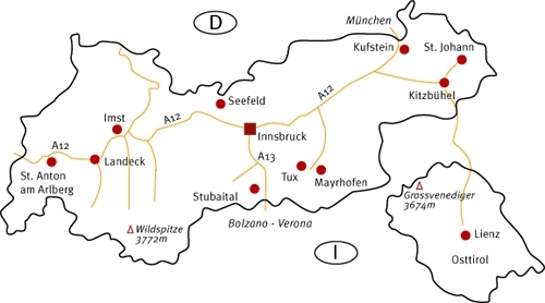
Grossvenediger - Grossvenediger

 Copia link
 www.tirolo.com


 1 / 4
1 / 4
Grossvenediger
 Planetmountain
Beauty

By
www.tirolo.com
Ascent height difference
1550m
Descent height difference
1550m
Height
3674m
Difficulty
Difficult
Time
7 - 8 hours
Period
Summer
Popularity
medium
Arrival
Grossvenediger
Route
An extraordinary outing up a series of glaciers to reach the 3000m summit of the highest peak in the Venediger mountain group.
Getting there
Starting village: Hinterbichl, Alti Tauri Access
Starting point: Refuge Johannishütte, 2121m Itinerary
From Hinterbichl take the taxibus to Refuge Johannishütte. Follow the marked path and cross the Zettalunitz river to then continue NE up the hill. The path soon steepens and zigzags uphill to quickly lead to the large glacial moraine at 1850m. Clearly visible deep below is the Zettalunitzkees glacier, and signs of the glacier's retreat can be easily made out. Continue along the path to reach a small plateau and the Refuge Defreggerhütte. Short zigzags lead up to this hut and the splendid view onto the Großvenediger and Hochgall - calculate 2 hours. After a brief rest continue past further zigzags up the final slope to reach the Rainerkees glacier. Rope up at this point and carefully cross the glacier, watching out for crevasse. The path is level at first but steepens as it nears the Rainertörl Follow the path across the snowy Schlatenkees slope to end up directly beneath the Großvenediger. A tiring and twisting path leads to the summit (beware of cornices) and, on clear days, the splendid views onto the Großglockner, Bernina and Ortles. Descent: return via the Rainertörl to the Defreggenhaus and Johannishütte mouhntain huts. Gear
Normal mountaineering gear. Take ice axe, crampons and rope for the glacier crossing. Notes
Further information: Tourist Office Prägraten am Großvenediger Tel. +43.4877.6366 www.tirol.at/praegraten Parco Nazionale degli Alti Tauri Tel. +43.4875.51610 www.hohetauern.at Maps/Bibliography
Kompass WK 46 Matrei in Osttirol-Kals am Großglockner Difficulty
For experienced mountaineers only. We strongly recommend a Mountain Guide for the glacier crossing.
 Comments
10/01/2014 Joepie Bos
Great mountain to walk/climb. Not difficult, but for inexpierenced walkers, please call a mountainguide. Because reaching the summit means crossing the glacier. For images see: http://www.youtube.com/watch?v=fl3xIx9IpSw
Beauty
By
www.tirolo.com
Ascent height difference
1550m
Descent height difference
1550m
Height
3674m
Difficulty
Difficult
Time
7 - 8 hours
Period
Summer
Popularity
medium
Arrival
Grossvenediger
Route
Routes in the same mountain group