Natalia Martínez
Volcan Aguilera, first ascent in Patagonia by the Uncharted expedition

 Copia link

 1 / 28Natalia Martínez
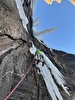
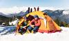
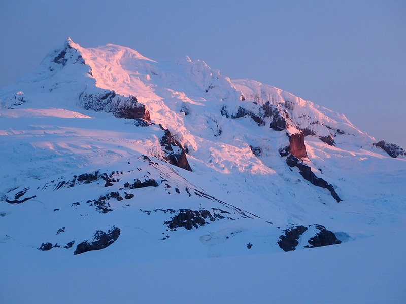
Although located only 10km from ocean access via Fiordo Peel, the approach’s dense vegetation and the region’s fickle weather had repulsed 6 previous month-long expeditions since 1986 (see historic background bellow), allowing only one team to even establish a camp at the mountain’s base. Taking note, the Uncharted team instead employed a counter-intuitive approach, starting from the Brazo Spegazzini of Lago Agrentino (Argentina) to traverse 47 km of icefield and opening new passes to arrive at the mountain’s untried north side. This entrance to the ice field was previously untried and proved to be a quick access to a wide area of poorly explored terrain. In a single 25-hour round-trip summit push, the team was able to negotiate the mountain’s towering seracs, gaping bergschrunds, and ice mushrooms to attain the summit at dusk on August 29th. Their route, Concierto de Rimayas, ascends the volcano’s north ridge before crossing onto the heavily-glaciated northwest face, and is named for the complex navigation required to find a path through the many fissures, passing around, over, and through at least 5 bergschrunds in variable weather including sun, snow, freezing rain, and wind.
Rest included exploration of volcanic formations on the mountain’s NE flank and a descent off the ice to vegetation while scoping future access routes from the nearby fjord. Then, taking advantage of extra rations and fantastic weather on their return journey, the team subsequently climbed 2 unnamed peaks (2420m, 2440m), Cerro Spegazzini’s East Peak (2290m), and Cerro Esperanza (2520m), all believed to be previously unclimbed.
The Uncharted project seeks to preserve exploration heritage and clarify errors and confusion in the exploratory history and maps of Patagonia’s mountain ranges, conducting extensive historical research and contacting members and family of prior expeditions before producing a high-quality topographic map highlighting the primary routes and correct peak names. Prior investigations and expeditions to the Cordillera de Darwin (2013) and the Cordillera de Sarmiento (2012) each resulted in significant ascents and corrections to geographic ambiguities. The Aguilera expedition has also identified several significant map errors for the seldom-visited region, and the team expects to clarify this confusion in their map after finishing their literature review.
Short background
First named by famed Italian explorer Alberto de Agostini in 1933, the peak was next visited by Bill Tilman himself and described in his 1957 book "Mischief in Patagonia".
Inspired by Tilman’s account, Matthew Hickman led the Anglo-Chilean Patagonian Expedition of 1985, which established the volcanic geology of the massif but was unable to carry out its intended field mapping activities.
The next attempt was done by a Japanese-Chilean team leaded by Eiho Otani in 1989.
In 1993, the expedition by Brit James "skip" Novak resulted in little gained knowledge, but whetted the appetite of Dr. David Hillebrandt, who made attempts on the peak in 2003, 2004, and 2005. These expeditions, though successful in determining an approach and possible ascent route via the South Ridge, were nonetheless hampered by the limited-detail maps of the region and the tenacious weather. The highest point attained on the massif is approximately 1291m according to Dr Hillebrandt’s GPS.
More recently, in 2013 a last attempt was made by a Chilean team leaded by Abdo Fernández, following a similar approach than the last expedition by Dr. Hillebrandt.
27/09/2013 - New route up Monte Sarmiento East: the second after this historic 1956 first ascent by Mauri and Maffei
Interview with Chilean alpinist Camilo Rada after the first ascent, carried out with Natalia Martinez from Argentina, of a new route up the North Face of Monte Sarmiento in Patagonia. Suerte de Sarmiento is only the second route to the East summit after the first ascent carried out by Clemente Maffei and Carlo Mauri in 1956.


 defended from the north by the Glaciar Peineta Norte seracs")


 See all photos
| Expo.Planetmountain | |
| Expo Marmot | |
| www | |
| uncharted.expenews.com | |