Giro De Sotecòrdes

 Copia link
 Mario Dibona, Mountain Guide


 1 / 2
1 / 2
Giro De Sotecòrdes
 Planetmountain
Beauty

By
Mario Dibona, Mountain Guide
Orientation
South
Ascent height difference
250m
Descent height difference
250m
Difficulty
Medium
Time
3 - 4 hours
Popularity
Medium
Route
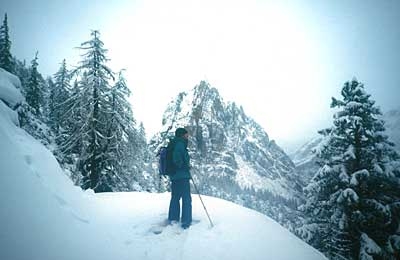
This is a classic itinerary that starts from the Passo Falzarego road and leads up to the south face of the Tofana di Rozes. This is one of the symbols of Cortina and its 3225m summit was first reached by the famous Viennese mountaineer P. Grohmann in 1864, together with the local Mountain Guides F. Lacedelli, A. Dimai and S. Siorpaes.
Getting there
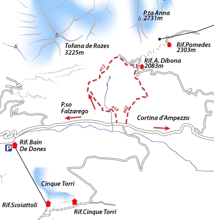
Reach Cortina. Access
Continue past Pocol and park immediately after the river Rio Bianco bridge, located close to "Cian Zopiè" and a “Parco Naturale delle Dolomiti d'Ampezzo” signpost. Itinerary
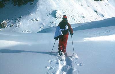
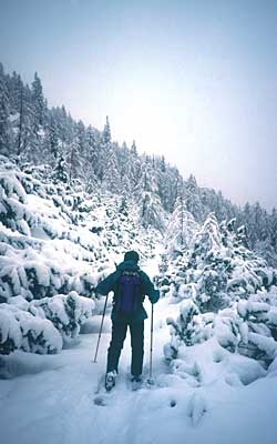
Follow path no. 414 easily uphill northwards, signposted Rif. Dibona. At the fork continue left following signs for the refuge, steeper than before, through the larch and fir trees which offer excellent protection for deer and chamois. A careful look at these trees reveals lichens, natural indicators of a clean, unpolluted habitat. Leave Rio Bianco to your right and continue climbing towards the base of the incredible Tofana di Rozes bastion. Coast alongside the river once more to reach a beautiful opening and "Cason de Sotcòrdes". Walk past the building (and excellent resting place) and head NE to an obvious path that leads to a large and beautiful small pine tree at 2000m. Close to the cables used to transport food up to rif. Giussani you are faced with a choice: either continue along the obvious path to Rif. Dibona, or descend directly down the wide valley to return to the path used earlier on in the day. This is reached via a fun abseil southwards to the river, which is then followed, on the left-hand bank, all the way back down to the path. For those proceeding to Rif. Dibona (2037m), continue down the obvious road to a hairpin bend and path no. 442 for "Cian Zopè – Cinque Torri". Flat at first, this then leads to a rocky shoulder, down rightwards to reach the main road SS 48 (1724m). Descent
The itinerary finishes where it started at "Cian Zopè”. Gear
Normal equipment for winter walking, snowshoes and poles. Binoculars recommended. Difficulty
No obvious danger. The itinerary can also be carried out during snowfalls.
Reach Cortina. Access
Continue past Pocol and park immediately after the river Rio Bianco bridge, located close to "Cian Zopiè" and a “Parco Naturale delle Dolomiti d'Ampezzo” signpost. Itinerary
Follow path no. 414 easily uphill northwards, signposted Rif. Dibona. At the fork continue left following signs for the refuge, steeper than before, through the larch and fir trees which offer excellent protection for deer and chamois. A careful look at these trees reveals lichens, natural indicators of a clean, unpolluted habitat. Leave Rio Bianco to your right and continue climbing towards the base of the incredible Tofana di Rozes bastion. Coast alongside the river once more to reach a beautiful opening and "Cason de Sotcòrdes". Walk past the building (and excellent resting place) and head NE to an obvious path that leads to a large and beautiful small pine tree at 2000m. Close to the cables used to transport food up to rif. Giussani you are faced with a choice: either continue along the obvious path to Rif. Dibona, or descend directly down the wide valley to return to the path used earlier on in the day. This is reached via a fun abseil southwards to the river, which is then followed, on the left-hand bank, all the way back down to the path. For those proceeding to Rif. Dibona (2037m), continue down the obvious road to a hairpin bend and path no. 442 for "Cian Zopè – Cinque Torri". Flat at first, this then leads to a rocky shoulder, down rightwards to reach the main road SS 48 (1724m). Descent
The itinerary finishes where it started at "Cian Zopè”. Gear
Normal equipment for winter walking, snowshoes and poles. Binoculars recommended. Difficulty
No obvious danger. The itinerary can also be carried out during snowfalls.

 Comments
05/02/2003 Andrea Pavan
La giornata era bellissima e il panorama splendido. La mia ragazza ed io abbiamo avuto delle difficoltà nella parte iniziale del percorso, alcune tracce non erano visibili, ma poco dopo abbiamo ritrovato il sentiero. Abbiamo visto 5 stambecchi di cui 3 adulti e 2 piccoli. In alcuni punti abbiamo dovuto togliere le ciaspe per assenza di neve.
26/02/2002 antonio benaglio
Percorso impegnativo nella sola parte iniziale, in salita, che può presentare alcune difficoltà di orientamento, in quanto i segni sugli alberi, gli unici visibili, non sono molto frequenti. Arrivati al cason de sotecordes,comunque, il gioco è ormai fatto.Si giunge infatti in breve con sentiero pianeggiante e poi in discesa al rifugio Dibona.Noi abbiamo trovato solamente le impronte di camosci (che abbiamo avvistato) e altri animali, quindi il percorso non deve essere molto frequentato nella prima parte.Bellezza 4, ma il giudizio potrebbe essere anche 5 per chi, più fortunato di noi, trovasse bel tempo.Consigliamo a tutti di provarlo.
Beauty
By
Mario Dibona, Mountain Guide
Orientation
South
Ascent height difference
250m
Descent height difference
250m
Difficulty
Medium
Time
3 - 4 hours
Popularity
Medium
Route
Routes in the same mountain group