Via Ferrata Gianni Aglio - Tofana di Mezzo

 Copia link
 Planetmountain.com


 1 / 3
1 / 3
Via Ferrata Gianni Aglio
 Planetmountain
Beauty


By
Planetmountain.com
Orientation
Southwest
Ascent height difference
800m
Ferrata height difference
350m
Height
3244m
Difficulty
Difficult
Time
3.30 hours
Period
From June to October, depending on snow conditions.
Popularity
high
Route
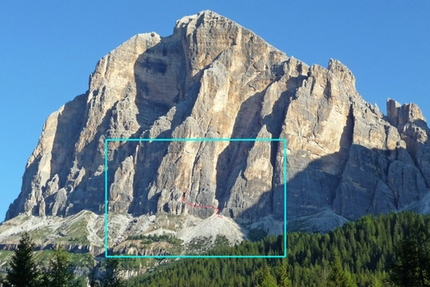
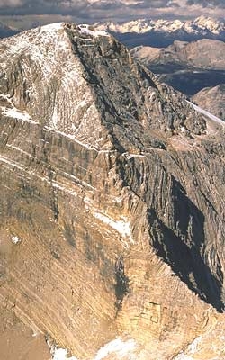
The ferrata leads up the highest of the three Tofane. When joined to the Giuseppe Olivieri ferrata at Punta Anna (see related itinerary) it makes up a long and difficult, but highly satisfying traverse for the well-trained. Even though the route is made easier by the cable car which leads to the summit, because of its height and the possibility of bad weather it shouldn’t be taken lightly.
Getting there
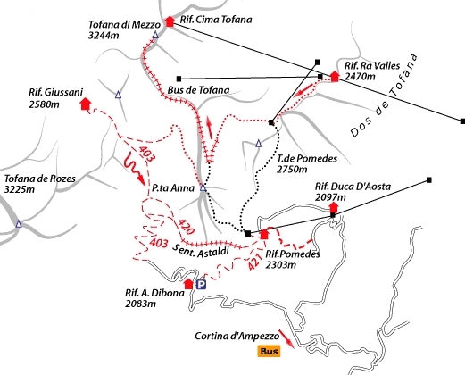
From Cortina take the “Freccia nel Cielo” cable car as far as the second station of Rif. Ra Valles. Access
The starting point, unless coming from the G. Olivieri Ferrata or the Sentiero attrezzato G. Olivieri, is the middle station of the Ra Valles cable car. From here, ignore signs for the “Olivieri” and Punta Anna, and ascend (SW) along the marked path to the Doss de Tofana, where the ferrata begins (2900m). Itinerary
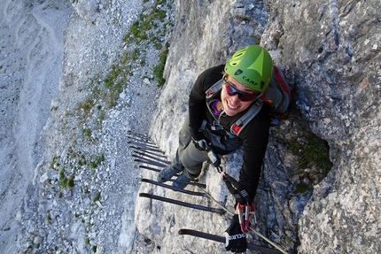
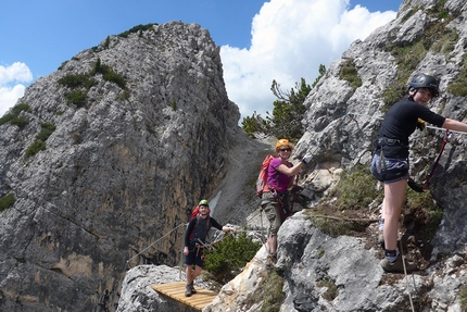
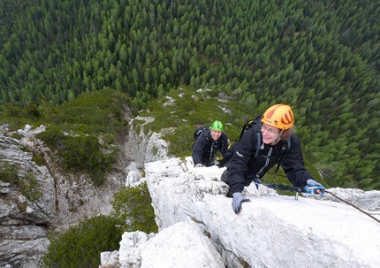
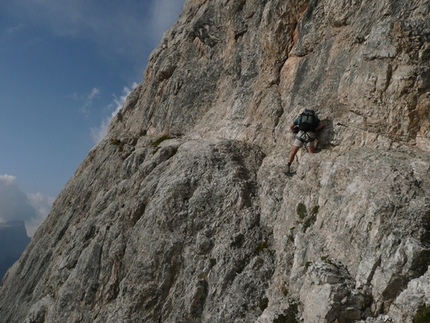
From the Doss de Tofana, after some steps and a vertical drop, equipped with a ladder, the itinerary leads onto the SW face and along ledges to the Torre Gianni Aglio gorge. Use the fixed cables to traverse the east face of the Torre (difficult and exposed, keep rope tight). After another airy traverse on the north face, reach the large Bus de Tofane “window” at 2920m up steps and rubble. It is possible to descend the scree slope from here to path no. 403, which links to Rifugio Giussani and Rifugio Dibona. For the summit, however, continue up slopes (at times snowy) and, after a ramp with avalanche barriers and two vertical drops equipped with ladders, follow the marked rocky path to the cross at the summit. Descent
Descend to the Rifugio Cima Tofana and the cable car station.
N.B. the last descent is at 16.00! Gear
Normal via ferrata kit. Maps/Bibliography
Via Ferratas of the Italian Dolomites: Vol 1 by John Smith and Graham Fletcher. Cicerone Press 2002 Difficulty
Not particularly difficult except on the exposed Torre Aglio traverse. The descent in the cable car considerably reduces the general effort required. Be careful at the beginning of the season as there may be still be snow and ice along the route.
From Cortina take the “Freccia nel Cielo” cable car as far as the second station of Rif. Ra Valles. Access
The starting point, unless coming from the G. Olivieri Ferrata or the Sentiero attrezzato G. Olivieri, is the middle station of the Ra Valles cable car. From here, ignore signs for the “Olivieri” and Punta Anna, and ascend (SW) along the marked path to the Doss de Tofana, where the ferrata begins (2900m). Itinerary
From the Doss de Tofana, after some steps and a vertical drop, equipped with a ladder, the itinerary leads onto the SW face and along ledges to the Torre Gianni Aglio gorge. Use the fixed cables to traverse the east face of the Torre (difficult and exposed, keep rope tight). After another airy traverse on the north face, reach the large Bus de Tofane “window” at 2920m up steps and rubble. It is possible to descend the scree slope from here to path no. 403, which links to Rifugio Giussani and Rifugio Dibona. For the summit, however, continue up slopes (at times snowy) and, after a ramp with avalanche barriers and two vertical drops equipped with ladders, follow the marked rocky path to the cross at the summit. Descent
Descend to the Rifugio Cima Tofana and the cable car station.
N.B. the last descent is at 16.00! Gear
Normal via ferrata kit. Maps/Bibliography
Via Ferratas of the Italian Dolomites: Vol 1 by John Smith and Graham Fletcher. Cicerone Press 2002 Difficulty
Not particularly difficult except on the exposed Torre Aglio traverse. The descent in the cable car considerably reduces the general effort required. Be careful at the beginning of the season as there may be still be snow and ice along the route.

 Comments
20/07/2015 Tobia Breda
Concatenata alla Olivieri è sicuramente un itinerario impegnativo dal punto di vista fisico. La ferrata è quasi tutta con protezioni nuove e si è sempre in totale sicurezza anche sulle selle di raccordo tra un massiccio e l'altro dove vi è una corda fissa (no cavo metallico), sospesa sopra la testa, a cui potersi agganciare. Mi sento di consigliare il rientro per il sentiero alpinistico (si lascia la ferrata tra la Tofana di Mezzo e di Dentro). Qui occhio alla neve (se presente) e girate a sinistra del laghetto o della conca (dipende se c'è neve o meno). Vedrete poi la traccia del sentiero ben evidente e numerosi ometti di pietra a segnalarlo. Arriverete poi ad un bunker alla forcella Valon (ottimo riparo d'emergenza) e da qui parte il magnifico ghiaione per una discesa veloce. Bellissimo.
26/07/2012 Claudio Sacchi
Questo commento NON riguarda la Tofana di Mezzo ma la Tofana di Dentro. Un itinerario interessantissimo, ma per esperti, ricalca alla rovescia il percorso di guerra del Capitano Barborka, dalla cima alla Cengia Paolina, tenendosi sempre sul versante W della Tofana.
Notizie nella relazione del CAI di Conegliano. Attenzione, pericolosa ma magnifica !!!
18/06/2009 Claudio Sacchi
Per chi non ama la folla, un grandioso itinerario (CENGIA PAOLINA) che si snoda in ambiente severo e da percorrere almeno in 2: da Rif. Giussani a dx ad imboccare la Cengia Sabelli, aggirare lo sperone Nemesis con meraviglioso scenario sulle Torri Travenanzes e Fanis, Potofana, Ra Ola, Ponte Cadoris. Il Canalone Ra Ola è magnifico da discendere a passi con scivolata, ma la continua frequentazione ne ha "usurato" lo strato mobile in ghiaino, peccato. Dopo i Cadoris il Ponte Alto con magnifica vista sull'orrido dei Rii Travenanzes e Fanis poi Podestagno e auto. Fate attenzione perchè l'itinerario è lungo, percorribile senza errori (cautela!) dove è in cengia, ma senza indicazioni nei 3 circhi sassosi, nel 2° dei quali potrete trovare, se siete fortunati i resti del ghiacciaio occidentale di Potofana; dappertutto ricordi di guerra. Circa 7 h calme
02/06/2009 Claudio Sacchi
Non ho mai capito come si sia potuto violentare la Tofana con una funivia che giunge proprio in cima per il piacere di pochi (?) smidollati che vanno lassù ad abbronzarsi con nessuna fatica, magari coi tacchetti apillo: che vengan loro le vesciche!
Ah! Das liebe Geld!!!
Alles Gute!
Tschüß
Beauty
By
Planetmountain.com
Orientation
Southwest
Ascent height difference
800m
Ferrata height difference
350m
Height
3244m
Difficulty
Difficult
Time
3.30 hours
Period
From June to October, depending on snow conditions.
Popularity
high
Route
Routes in the same mountain group