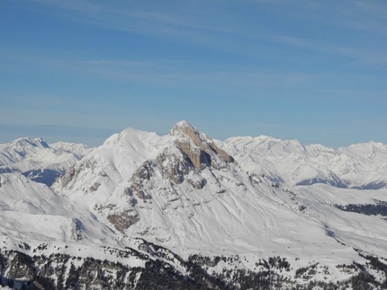
Munt da Medalges

 Copia link
 Enrico Baccanti and Francesco Tremolada, Alta Badia Guides


 1 / 3
1 / 3
Munt da Medalges: © Enrico Baccanti
 Planetmountain
Beauty


By
Enrico Baccanti and Francesco Tremolada, Alta Badia Guides
Ascent height difference
900m
Descent height difference
900m
Height
2454m
Difficulty
ALP: E, SKI: 1.3, Exp: E1
Time
3 h
Descent exposition
E+S
Departure
Longiarù in Val Badia
A winter itinerary, easy and safe which is ideal as the season’s first ski mountaineering trip.
Access
The starting point is Longiarù in Val Badia. Longiarù is reached from San Martino in Badia, which can be easily reached by turning onto the road (244) which joins Brunico to the villages in Alta Badia. Once you cross the town of Longiarù follow the road for Seres and Miscì, till you reach the evident car park (roughly 1536 metres). Itinerary
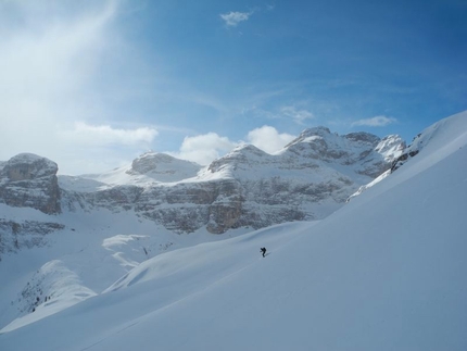
From the car park turn onto the dirt road (marked n°5) which heads into the valley. Before entering the woods, leave the road and detour to the right climbing up the summer path which helps you gain vertical height with a more direct route. Either by following the path or along the road you will finally reach the wide open slopes above the valley, which in a westerly direction goes past many huts, till you reach the Medalges farm house. From the farm, which can be reached with a last steeper section, continue towards the nearby Forcella Furcia 2293m, to then detour to the right climbing up directly to the panoramic summit. Descent
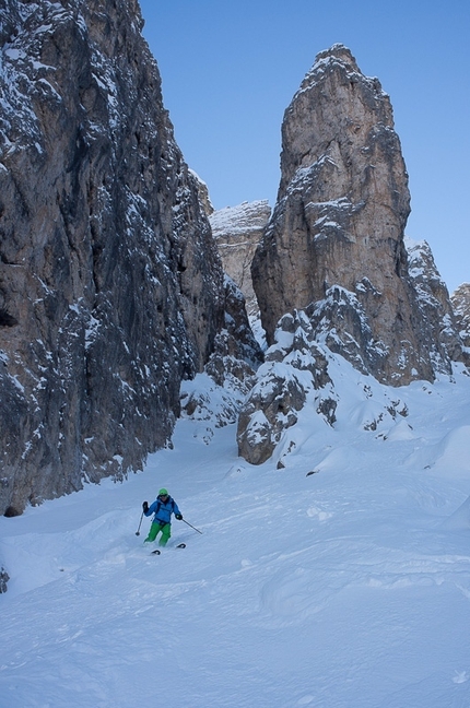
From the summit directly ski down the slopes below, towards the farm; from here continue first of all along the uphill route, then lower down directly towards the valley, skiing along the slopes near the road (marked 5a), along which you return back to the starting point. Notes
Easy itinerary, which is very long. Other possibilities: From the farm, with safe snow, you can ski directly down towards the valley following the open and inviting slopes below. Once you have entered the woods turn onto the path/road (marked 5a) which goes to the left (East), with a few slightly uphill sections, takes you back to the road. Maps/Bibliography
The starting point is Longiarù in Val Badia. Longiarù is reached from San Martino in Badia, which can be easily reached by turning onto the road (244) which joins Brunico to the villages in Alta Badia. Once you cross the town of Longiarù follow the road for Seres and Miscì, till you reach the evident car park (roughly 1536 metres). Itinerary
From the car park turn onto the dirt road (marked n°5) which heads into the valley. Before entering the woods, leave the road and detour to the right climbing up the summer path which helps you gain vertical height with a more direct route. Either by following the path or along the road you will finally reach the wide open slopes above the valley, which in a westerly direction goes past many huts, till you reach the Medalges farm house. From the farm, which can be reached with a last steeper section, continue towards the nearby Forcella Furcia 2293m, to then detour to the right climbing up directly to the panoramic summit. Descent
From the summit directly ski down the slopes below, towards the farm; from here continue first of all along the uphill route, then lower down directly towards the valley, skiing along the slopes near the road (marked 5a), along which you return back to the starting point. Notes
Easy itinerary, which is very long. Other possibilities: From the farm, with safe snow, you can ski directly down towards the valley following the open and inviting slopes below. Once you have entered the woods turn onto the path/road (marked 5a) which goes to the left (East), with a few slightly uphill sections, takes you back to the road. Maps/Bibliography

 Comments
No comments yet...
Beauty
By
Enrico Baccanti and Francesco Tremolada, Alta Badia Guides
Ascent height difference
900m
Descent height difference
900m
Height
2454m
Difficulty
ALP: E, SKI: 1.3, Exp: E1
Time
3 h
Descent exposition
E+S
Departure
Longiarù in Val Badia
Routes in the same mountain group

Related news
07/03/2013 - Snow Ski-skimountaineering
Dolomites ski mountaineering: the Puez Odle group Four ski mountaineering routes in the Puez Odle group of the Dolomites presented by Enrico Baccanti and Francesco Tremolada, Alta Badia Guides: Antersasc North Gully, Crep da le Dodesc, Munt...