Langschneid

 Copia link
 Vittorio Messini, Mountain Guide Kals am Großglockner


 1 / 5
1 / 5
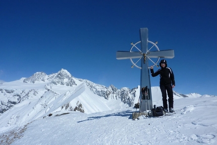
Langschneid: Langschneid (2688m): the summit © Guide Alpine Kals am Großglockner
 Planetmountain
Beauty


By
Vittorio Messini, Mountain Guide Kals am Großglockner
Ascent height difference
870m
Descent height difference
1525m
Height
2688m
Difficulty
Intermediate
Ascent exposition
East
Descent exposition
East (1st option) NNW (2nd option)
Period
December - April
Departure
St. Jakob in Defereggental
Beautiful "bonus ski-tour which, thanks to the ski lift, offers 870m vertical height gain and a massive 1525m descent. In safe conditions the second descent variation is fantastic but only recommended for expert skiers.
Access
How to reach East Tirol (Osttirol, Austria):
1) From Munich or Verona via the Brenner motorway to exit at Bressanone. Drive through the Pusteria valley to reach the Italian-Austrian border. Continue from here past Lienz towards Felbertauern to reach the starting points in about 1 hour.
2) From Munich to Salzburg, then continue south to Bischofshofen. Leave the motorway here and drive through the Salzachtal to reach Mittersill. From here take the the Felbertauern road, through the tunnel, to enter the East Tirol.
Continue by car to the nearby village St. Jakob in Defereggental and park at bottom of the ski lifts. Itinerary
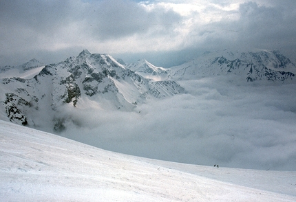
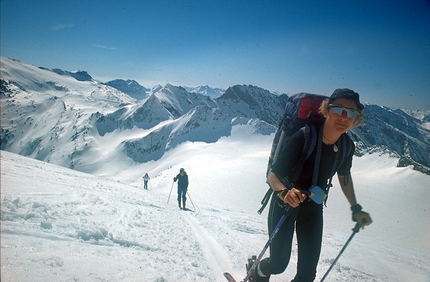
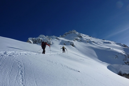
We take the lift to the highest point at about 2300m above sea level. From here we ski down the piste for 500m to reach the Bruggeralm (1818m) from where our ascent starts: follow the summer path up to the Ragothalm, where the landscape opens up onto marvellous slopes. We ascend this valley to reach the Ragothlenke pass and enjoy the view onto the highest mountain in the area, Mount Hochgall. From here we follow the easy crest northwards to easily reach the top of Langschneid. Descent
There are two descent options: either ski down the ascent route (this is the safest option) or descend via the steeper (circa 35° - 45°), fantastic powder slopes to the north – north east. With a descent of circa 1500m and an ascent of just 870m (thanks to the ski lift), this is certainly one of the ski touring highlights in the Defereggen valley. However, this second descent can only be carried out in safe snow conditions and careful assessment of an expert is therefore paramount! Notes
Contact the Alpine Guides Kals am Großglockner: www.bergfuehrer-kals.at
East Tirol Tourist office: www.osttirol.com Maps/Bibliography
For the Langschneid there are two maps: Freytag&Berndt (WK 123) or ÖK Blatt Nr.178
New for 2012: the ski touring guidebook of East Tirol by Thomas Mariacher
How to reach East Tirol (Osttirol, Austria):
1) From Munich or Verona via the Brenner motorway to exit at Bressanone. Drive through the Pusteria valley to reach the Italian-Austrian border. Continue from here past Lienz towards Felbertauern to reach the starting points in about 1 hour.
2) From Munich to Salzburg, then continue south to Bischofshofen. Leave the motorway here and drive through the Salzachtal to reach Mittersill. From here take the the Felbertauern road, through the tunnel, to enter the East Tirol.
Continue by car to the nearby village St. Jakob in Defereggental and park at bottom of the ski lifts. Itinerary
We take the lift to the highest point at about 2300m above sea level. From here we ski down the piste for 500m to reach the Bruggeralm (1818m) from where our ascent starts: follow the summer path up to the Ragothalm, where the landscape opens up onto marvellous slopes. We ascend this valley to reach the Ragothlenke pass and enjoy the view onto the highest mountain in the area, Mount Hochgall. From here we follow the easy crest northwards to easily reach the top of Langschneid. Descent
There are two descent options: either ski down the ascent route (this is the safest option) or descend via the steeper (circa 35° - 45°), fantastic powder slopes to the north – north east. With a descent of circa 1500m and an ascent of just 870m (thanks to the ski lift), this is certainly one of the ski touring highlights in the Defereggen valley. However, this second descent can only be carried out in safe snow conditions and careful assessment of an expert is therefore paramount! Notes
Contact the Alpine Guides Kals am Großglockner: www.bergfuehrer-kals.at
East Tirol Tourist office: www.osttirol.com Maps/Bibliography
For the Langschneid there are two maps: Freytag&Berndt (WK 123) or ÖK Blatt Nr.178
New for 2012: the ski touring guidebook of East Tirol by Thomas Mariacher
 Comments
No comments yet...
Beauty
By
Vittorio Messini, Mountain Guide Kals am Großglockner
Ascent height difference
870m
Descent height difference
1525m
Height
2688m
Difficulty
Intermediate
Ascent exposition
East
Descent exposition
East (1st option) NNW (2nd option)
Period
December - April
Departure
St. Jakob in Defereggental
Routes in the same mountain group

Related news

09/01/2012 - Snow Ski-skimountaineering
Ski mountaineering in the Upper Tauern, East Tirol, Austria Figerhorn, Langschneid and Hochgasser, three ski mountaineering itineraries in the Upper Tauern, East Tirol, Austria, introduced by Vittorio Messini, Mountain Guide Kals am Großglockner.