Glacier Rond

 Copia link
 Domenico Giusti, Giorgio Passino


 1 / 3
1 / 3
Glacier Rond: Henry Barkhausen / Pro Guiding Service
 Planetmountain
Beauty

By
Domenico Giusti, Giorgio Passino
Ascent height difference
70m
Descent height difference
1690m
Difficulty
5.1, E3
Descent exposition
NW
Route
Even though it is one of the classic Chamonix descents, the Glacier Rond is a technical itinerary that requires good ropework and experience with glacier skiing techniques.
Be careful on the traverse to enter the initial couloir, as it’s often icy. Both variants are exposed to the risks of avalanches.
Getting there
Start in Chamonix. Access
Aiguille du Midi Cable Car. Take both sections of the cable up to the Aiguille du Midi Station. Itinerary
Start in Chamonix. Access
Aiguille du Midi Cable Car. Take both sections of the cable up to the Aiguille du Midi Station. Itinerary
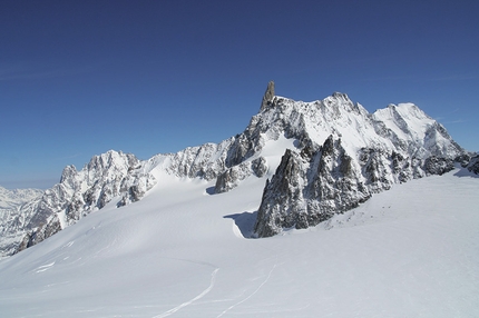
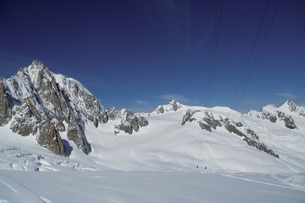
1. From the exit of the Aiguille du Midi station, descend on foot along the ridge that leads to a large plateau below: during winter season, the descent track is protected by fixed ropes. For a more comfortable descent, it’s advisable to strap the skis to the pack. For additional safety, it’s worth considering using crampons and, if necessary, roping up. 2. On the plateau, put the skis on and start descending on the right, skirting the south face of the Aiguille du Midi.
3. Once the Cosmiques Hut becomes visible, stay on the right of it and start climbing the ramp between the Cosmiques Hut and the Abri Simond. 4. On the top, depending on the snow conditions, you can put skis on and traverse right to reach the top of the glacier (beware as the traverse is very exposed on the left side and often icy) or traverse on foot wearing crampons.
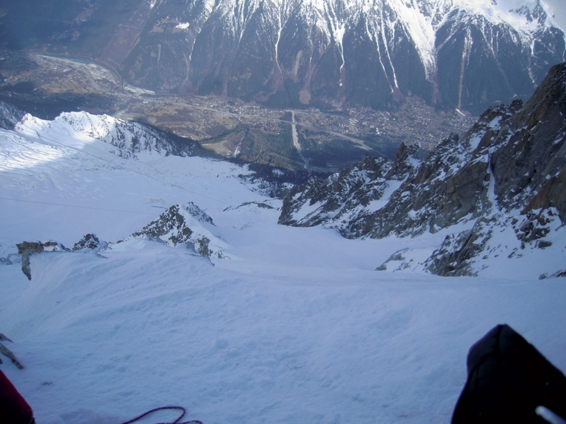
5. The descent starts from a ridge with a steep wall on the right. Start the descent, which is steep in the first section, taking particular care of the snow conditions: in general, the left side of the wall offers better snow.
6. After approximately 400m of descent, traverse left towards the exit couloir. Depending on snow conditions, you can either ski into the couloir directly or you may have to abseil for a few metres.
7. Ski the couloir all the way down. At the end of the couloir, traverse right to reach the Bossons Glacier. Be careful on exiting it: depending on snow quality, the crevasses can be more or less open and you may have to make a number of deviations to avoid them.
8. To exit the glacier, people usually skirt the rocky ridge on the right. Once out of crevasses, two variants are possible:
[V1 Chamonix] Continue skiing towards Chamonix, crossing the woods until the Mont Blanc Tunnel, and then go back to Chamonix by car (if you parked it nearby) or hitchhike.
[V2 Plan de l’Aiguille] Traverse right to reach the mid-station of the Aiguille du Midi Cable Car: depending on snow pack, you may have to sidestep a few times to reach the right altitude.
Maps/BibliographyMONT BLANC FREERIDE
48 itinerari di freeride nelle vallate di Courmayeur e Chamonix
di Domenico Giusti, Giorgio Passino, Idea Montagna Editoria e Alpinismo
Note: Italian, French, English
ISBN: 9788897299370
 Comments
No comments yet...
Beauty
By
Domenico Giusti, Giorgio Passino
Ascent height difference
70m
Descent height difference
1690m
Difficulty
5.1, E3
Descent exposition
NW
Route
Routes in the same mountain group
Show more in Mont Blanc
Related news
16/12/2013 - Snow Ski-skimountaineering
Mont Blanc freeride: Vallée Blanche and Glacier Rond Two great freeride itineraries on Mont Blanc introduced by Domenico Giusti and Giorgio Passino: Vallée Blanche from Courmayeur and Glacier Rond.