Via Ferrata Bocchette Centrali - Cima Brenta Alta

 Copia link
 Planetmountain.com


 1 / 7
1 / 7
Via Ferrata Bocchette Centrali: © Nicholas Hobley
 Planetmountain
Beauty

By
Planetmountain.com
Orientation
East-West
Ascent height difference
600m
Ferrata height difference
400m
Height
2550 - 2800m
Difficulty
Medium
Time
4.30 hours from Rifugio Alimonta to Rifugio dei Brentei.
Period
June to October
Popularity
High
Route
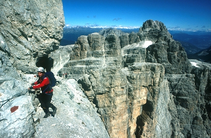
Together with the Via Ferrata delle Bocchette Alte the Via Ferrata delle Bocchette Centrali is rightly considered one of the most beautiful ferrate in the Brenta Dolomites. Crossing wild, exposed, but always well-equipped ledges, on clear days the view east extends from Lago di Molveno all the way to Civetta and the Marmolada, and west to Campanile Alto and the majestic Campanile Basso. Although a ferrata in its own right, it is also the natural second-day progression of the Via delle Bocchette Alte. After a night spent in one of the refuges, ideally Rifugio Alimonta, it guarantees an outing long to be remembered.
Getting there
From Madonna di Campiglio drive to Rifugio Vallesinella (1513m). Access
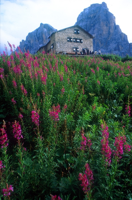
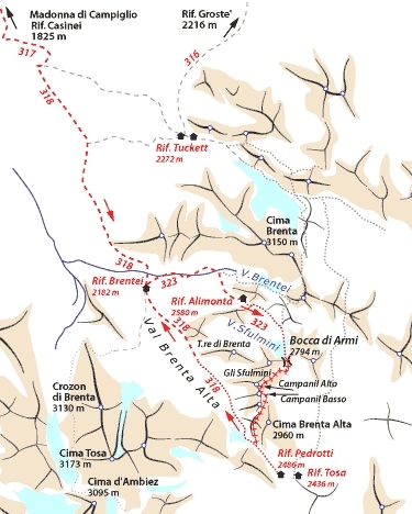
From Rifugio Vallesinella (1513m) take path no. 317 to Rifugio Casinei (1825m) and then continue on path no. 318 Sentiero dei Brentei in two hours to Rifugio dei Brentei (2182m). From here in one hour to Rifugio Alimonta (2580m). Itinerary
From Rifugio Alimonta (2580m) begin easily up path no. 323 past the Sfulmini glacier (care required on hard-packed snow in the morning) to the windy Bocca di Armi and the start of the Via Ferrata (30 mins). Reach the ledge after a few ladders and continue past cables onto the east face of Torre di Brenta. Exposed but finally sheltered from the wind, this is the true start of the long ledge traverse of the Bocchette Centrali. It soon leads to the most difficult section of the ferrata, the exciting horseshoe shaped ledge of the sentiero Figari. The sheer drop is staggering and the ledge is only 50cm wide at this point, but cables lead safely to beneath the Sfulmini, the impressive view onto Campanile Alto and the fantastic Campanile Basso. The path now leads downwards along the east face, around Campanile Alto (excellent rest point with view) to zigzag past wet boulders and across a small snow patch. Continue past this deep into the majestic world of the Brenta Dolomites to almost touch the mythical Campanile Basso, first climbed by the Austrians Ampferer and Berger in 1899. The silence is interrupted only by shouts from climbers high above and the wind which now blows across the col. Climb up the short but sometimes slippery slope to this saddle, to then descend right onto the west face of the Cima Brenta Alta. Polished steps and ladders lead down to another ledge: follow this easily and enjoy the splendid view onto Cima Tosa and Crozzon di Brenta to reach the final ladders and the glacier below. Descent
Once on the glacier beneath the Bocca di Brenta return easily along Sentiero dei Brentei (no. 318) to Rifugio dei Brentei (2182m, 1 hour) and then on to Rifugio Vallesinella and the car park in a further 1.30 hours. Alternativly, climb up to Bocca di Brenta and descend to Rifugio Tommaso Pedrotti (2491m). This acts as a formidable base for other ferrate in the Brenta region, or as a well-deserved rest for those who chose to take the long path up from Molveno. Gear
Normal via ferrata kit. Ice axe and crampons necessary at the start of the season Maps/Bibliography
Via Ferratas of the Italian Dolomites: Vol 2 by John Smith and Graham Fletcher. Cicerone Press 2002 Difficulty
Not particularly difficult but exposed itinerary. Well-equipped throughout.
From Madonna di Campiglio drive to Rifugio Vallesinella (1513m). Access
From Rifugio Vallesinella (1513m) take path no. 317 to Rifugio Casinei (1825m) and then continue on path no. 318 Sentiero dei Brentei in two hours to Rifugio dei Brentei (2182m). From here in one hour to Rifugio Alimonta (2580m). Itinerary
From Rifugio Alimonta (2580m) begin easily up path no. 323 past the Sfulmini glacier (care required on hard-packed snow in the morning) to the windy Bocca di Armi and the start of the Via Ferrata (30 mins). Reach the ledge after a few ladders and continue past cables onto the east face of Torre di Brenta. Exposed but finally sheltered from the wind, this is the true start of the long ledge traverse of the Bocchette Centrali. It soon leads to the most difficult section of the ferrata, the exciting horseshoe shaped ledge of the sentiero Figari. The sheer drop is staggering and the ledge is only 50cm wide at this point, but cables lead safely to beneath the Sfulmini, the impressive view onto Campanile Alto and the fantastic Campanile Basso. The path now leads downwards along the east face, around Campanile Alto (excellent rest point with view) to zigzag past wet boulders and across a small snow patch. Continue past this deep into the majestic world of the Brenta Dolomites to almost touch the mythical Campanile Basso, first climbed by the Austrians Ampferer and Berger in 1899. The silence is interrupted only by shouts from climbers high above and the wind which now blows across the col. Climb up the short but sometimes slippery slope to this saddle, to then descend right onto the west face of the Cima Brenta Alta. Polished steps and ladders lead down to another ledge: follow this easily and enjoy the splendid view onto Cima Tosa and Crozzon di Brenta to reach the final ladders and the glacier below. Descent
Once on the glacier beneath the Bocca di Brenta return easily along Sentiero dei Brentei (no. 318) to Rifugio dei Brentei (2182m, 1 hour) and then on to Rifugio Vallesinella and the car park in a further 1.30 hours. Alternativly, climb up to Bocca di Brenta and descend to Rifugio Tommaso Pedrotti (2491m). This acts as a formidable base for other ferrate in the Brenta region, or as a well-deserved rest for those who chose to take the long path up from Molveno. Gear
Normal via ferrata kit. Ice axe and crampons necessary at the start of the season Maps/Bibliography
Via Ferratas of the Italian Dolomites: Vol 2 by John Smith and Graham Fletcher. Cicerone Press 2002 Difficulty
Not particularly difficult but exposed itinerary. Well-equipped throughout.


 See all photos
 Comments
06/06/2008 carlo giorgioni
Non difficile, ma super-super panoramica, con viste a strapiombo su Molveno, e passaggio a fianco del Campanil Basso
18/04/2008 STEFANO BARTESAGHI
FERRATA A MOZZAFIATO, CON DEI BELLISSIMI PASSAGGI AEREI, E CON CENGE CARATTERISTICHE, OTTIMO PAESAGGIO, CON LA VEDUTA ALLA STUPENDA TORRE DEL BRENTA, QUESTA FERRATA LA CONSIGLIO A TUTTI
23/10/2007 Mirko Tomassini
bellissima in questo periodo con alcune vette innevate. Necessaria la piccozza se si sale dall'alimonta.
26/08/2007 Maurizio Suzzani
Dire fantastica è troppo poco, percorsa in una splendida mattina con partenza dal Pedrotti, quindi arrivo all'Alimonta e a seguire, il SOSAT sino al Tucket. Un percorso indimenticabile! A mio avviso da percorrere solo con certezza di bel tempo senza rischi di temporali. Non ci sono vie di fuga !
Beauty
By
Planetmountain.com
Orientation
East-West
Ascent height difference
600m
Ferrata height difference
400m
Height
2550 - 2800m
Difficulty
Medium
Time
4.30 hours from Rifugio Alimonta to Rifugio dei Brentei.
Period
June to October
Popularity
High
Route
Routes in the same mountain group