Figerhorn

 Copia link
 Vittorio Messini, Mountain Guide Kals am Großglockner


 1 / 3
1 / 3
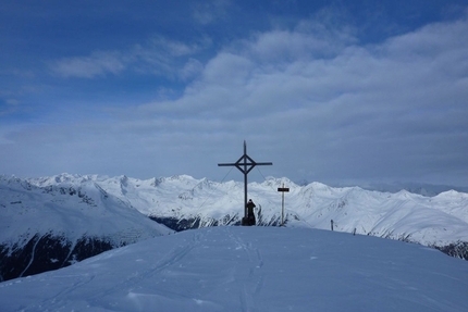
Figerhorn: Figerhorn (2743m): on the summit, with Grossglockner in the background. © Kals am Großglockner Mountain Guides
 Planetmountain
Beauty


By
Vittorio Messini, Mountain Guide Kals am Großglockner
Ascent height difference
900m
Descent height difference
900m
Height
2743m
Difficulty
Easy
Ascent exposition
South
Descent exposition
South
Period
December - April
Departure
Kals am Großglockne
The Figerhorn is a beautiful ski mountaineering tour. South facing and with only 900m vertical height gain, it is ideal for beginners.
Access
How to reach East Tirol (Osttirol, Austria):
1) From Munich or Verona via the Brenner motorway to exit at Bressanone. Drive through the Pusteria valley to reach the Italian-Austrian border. Continue from here past Lienz towards Felbertauern to reach the starting points in about 1 hour.
2) From Munich to Salzburg, then continue south to Bischofshofen. Leave the motorway here and drive through the Salzachtal to reach Mittersill. From here take the the Felbertauern road, through the tunnel, to enter the East Tirol.
Our starting point is Kals am Grossglockner. Follow the road to the Lucknerhaus (the car park for Großglockner) and park the car circa 0.5 km before the Lucknerhaus, on the right. Itinerary
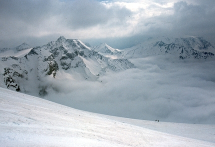
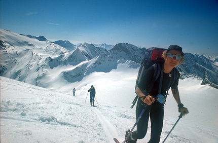
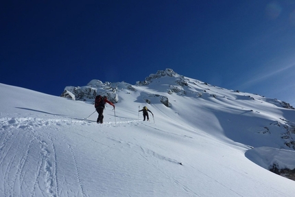
We put our skis on and ascend the road that leads to the tree line. Wide, gentle slopes open up here, about 25° to 30° steep and we continue up these which seem to have been created perfectly for ski touring, to reach the so-called "Graiwiesen". We leave our skis here and continue on foot, firstly up a steeper slope, then along the easy crest that leads to the summit. Descent
With about 900m vertical height gain, a south facing aspect and ideally angled slopes, the Figerhorn ski tour is ideal for beginners but also for advanced skiers if avalanche conditions are not suitable for more demanding itineraries. Notes
Contact the Alpine Guides Kals am Großglockner: www.bergfuehrer-kals.at
East Tirol Tourist office: www.osttirol.com Maps/Bibliography
For the Figerhorn we recommended the Austrian Alpine Club map (AV Karte Nr. 36 Venedigergruppe).
New for 2012: the ski touring guidebook of East Tirol by Thomas Mariacher
How to reach East Tirol (Osttirol, Austria):
1) From Munich or Verona via the Brenner motorway to exit at Bressanone. Drive through the Pusteria valley to reach the Italian-Austrian border. Continue from here past Lienz towards Felbertauern to reach the starting points in about 1 hour.
2) From Munich to Salzburg, then continue south to Bischofshofen. Leave the motorway here and drive through the Salzachtal to reach Mittersill. From here take the the Felbertauern road, through the tunnel, to enter the East Tirol.
Our starting point is Kals am Grossglockner. Follow the road to the Lucknerhaus (the car park for Großglockner) and park the car circa 0.5 km before the Lucknerhaus, on the right. Itinerary
We put our skis on and ascend the road that leads to the tree line. Wide, gentle slopes open up here, about 25° to 30° steep and we continue up these which seem to have been created perfectly for ski touring, to reach the so-called "Graiwiesen". We leave our skis here and continue on foot, firstly up a steeper slope, then along the easy crest that leads to the summit. Descent
With about 900m vertical height gain, a south facing aspect and ideally angled slopes, the Figerhorn ski tour is ideal for beginners but also for advanced skiers if avalanche conditions are not suitable for more demanding itineraries. Notes
Contact the Alpine Guides Kals am Großglockner: www.bergfuehrer-kals.at
East Tirol Tourist office: www.osttirol.com Maps/Bibliography
For the Figerhorn we recommended the Austrian Alpine Club map (AV Karte Nr. 36 Venedigergruppe).
New for 2012: the ski touring guidebook of East Tirol by Thomas Mariacher
 Comments
No comments yet...
Beauty
By
Vittorio Messini, Mountain Guide Kals am Großglockner
Ascent height difference
900m
Descent height difference
900m
Height
2743m
Difficulty
Easy
Ascent exposition
South
Descent exposition
South
Period
December - April
Departure
Kals am Großglockne
Routes in the same mountain group

Related news

09/01/2012 - Snow Ski-skimountaineering
Ski mountaineering in the Upper Tauern, East Tirol, Austria Figerhorn, Langschneid and Hochgasser, three ski mountaineering itineraries in the Upper Tauern, East Tirol, Austria, introduced by Vittorio Messini, Mountain Guide Kals am Großglockner.