Via Ferrata Vallon Bianco - Monte Vallon Bianco

 Copia link
 Planetmountain.com


 1 / 9
1 / 9
Via Ferrata Vallon Bianco
 Planetmountain
Beauty


By
Planetmountain.com
Orientation
North
Ascent height difference
1330m - 700m
Ferrata height difference
300m
Height
2684m
Difficulty
Medium
Time
9 hours from Pian de Loa. 6 hours from Rif. Fanes
Period
From July to September, depending on snow conditions.
Popularity
low
Route

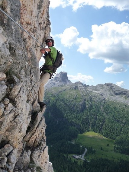
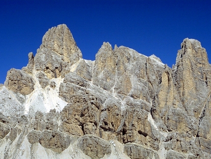
The wide Vallon Bianco summit marks the Fanes’ outer edge and is an outstanding observation point for the Travenazes valley, the Tofane, Croda Rossa, the Fanes valley and even the furthest alpine peaks. The ascent is not difficult and although equipped in sections, should be undertaken only by fit walkers, especially if starting from Pian de Loa (Cortina). The itinerary can be split into two by spending the night at Rifugio Fanes. Just like nearby Furcia Rossa, the ferrate crosses the front held by the Austrian’s during the First World War. Combing the two results in a magnificent (even if extremely long and demanding) traverse at altitude.
Getting there
1) From Passo Falzarego or S. Cassiano take the Passo di Valparola road and turn off (north) at the Ru Sciare bridge to reach Capanna Alpina all’Armentarola (1726 m).
2) From S. Vigilio di Marebbe drive to Rifugio Pederù. Access
1) From Capanna Alpina take path no. 11 and cross Plan de Furcia to climb swiftly up to Col de Lòcia (2069 m). Continue past Passo Tadega (2157 m) and descend slightly to Alpe Fanes Grande (2 hrs). Take the path marked VB17 rightwards to ascend to Vallon del Fosso and, at a source (2402 m – 1 hr) follow the markers (VB).
2) From Rif. Pederù walk to Rif Fanes (2060m) and proceed to Alpe di Fanes Grande (2 hrs). Continue from here as described above. Itinerary
From Alpe di Fanes Grande follow path no.17 southeast to ascend Vallon del Fosso. At the source (2402 m) follow the obvious VB markers for Vallon Bianco (FR leads away to Furcia Rossa). Continue past the obvious VB markers up several hairpin bends, after which the path turns left and traverses the north face of Vallon Bianco’s main crest. After a small metal bridge it then leads across exposed terrain, equipped in sections, to beneath the summit cross. The remains of military positions can still be seen nestled into the mountain, and were used by the Austrian to control the valle di Travenanzes and the Italian front during the Great War. Descent
Descend as for the ascent. Gear
Normal via ferrata kit. Maps/Bibliography
Via Ferratas of the Italian Dolomites: Vol 1 by John Smith and Graham Fletcher. Cicerone Press 2002 Difficulty
This wild and solitary itinerary should is recommended for fit walkers, especially if starting from Pian de Loa. Experience on this type of terrain is essential, especially since some of the ferrate may not be in ideal condition.


 See all photos
 Comments
10/07/2001 Francesco Piardi
Bellissimo itinerario in ambiente isolato. La ferrata non e' impegnativa anche se esposta. Il panorama sulla Val Trevenanzes e le Tofane e' superlativo. Trovata qualche chiazza di neve.
Beauty
By
Planetmountain.com
Orientation
North
Ascent height difference
1330m - 700m
Ferrata height difference
300m
Height
2684m
Difficulty
Medium
Time
9 hours from Pian de Loa. 6 hours from Rif. Fanes
Period
From July to September, depending on snow conditions.
Popularity
low
Route
Routes in the same mountain group