Morgenkogel

 Copia link
 Roberto Iacopelli, Mountain Guide. Taken from the book 'Scialpinismo in Tirolo' Ed. Versante Sud


 1 / 2
1 / 2
Morgenkogel
 Planetmountain
Beauty


By
Roberto Iacopelli, Mountain Guide. Taken from the book 'Scialpinismo in Tirolo' Ed. Versante Sud
Ascent height difference
1568m
Descent height difference
1568m
Height
2607m
Difficulty
Medium
Time
3 - 5 hours
Ascent exposition
W, N
Descent exposition
N
Route
With Morgenkogel we enter the mountains of Innsbruck’s skiers. Among the various classical itineraries within the city’s surroundings this is one of the closest. Reachable in just over fifteen minutes from the centre, this itinerary together with the nearby Kreuzspitze, is a strictly winter trip with a remarkable vertical height gain and total length. Morgenkogel especially is characterised by slopes which are never too steep and therefore ideal during the central winter months when the avalanche conditions keep us away from more accentuated gradients. We carried out this trip on Christmas Eve after an abundant snowfall. There was so much powder snow that it seemed as if we were descending on a motorboat! This was a well deserved prize after having made tracks in deep snow all the way up. This long distance and vertical height gain can be softened by sleeping overnight at the cosy Meissner Haus refuge (1707 m.) - www.meissner-haus.at - telephone: 0043 6508511430, which is part of the Innsbruck Alpenverein (Alpine Club) and is usually open throughout the winter season. I particularly recommend this trip if you have a large group to lead, with such an itinerary you will surely please everyone!
Access
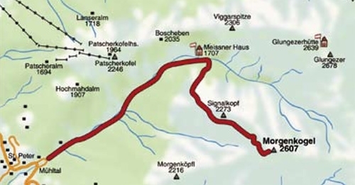
From Innsbruck drive north towards Italy, exit the motorway at Matrei and continue north to Mühltal and Ellbögen. Itinerary
At Mühltal leave the road at the bend which goes up to the small and rugged inhabited area as far as the car park. From here take the long valley road, which during winter is a sledge run, going up to the Meissner Haus. Where the road descends to the left to reach the refuge you continue a short way before briefly starting to climb through the woods to the right. In the first section the itinerary is not obligatory, most probably it will already be tracked, nonetheless following a diagonal ascent amongst woods and clearings you will after a certain point reach red poles (sign posts). Follow these markings which indicate the safest tracks in an environment which becomes very vast when it opens up away from the vegetation. Going around Signalkopf (2273 m.) cross long, leaning slopes till you go up a ridge which takes you directly to the summit. The view over the valleys of the Inn and Wipptal are beautiful if the weather is good, but be careful in case of scarce visibility as there could be problems of orientation. Descent
From a practical point of view you can descend Morgenkogel from all sides; Arztal’s southern side is the steepest and therefore it cannot be skied when avalanche danger is high. I point this out because you will notice that on the map there a number of possibilities marked as inviting ski mountaineering itineraries which take you back to Wipptal, even if most probably you will descend down the ascent route just like almost everyone else, and it seems to be the best solution in terms of skiing. Gear
Normal ski mountaineering equipment Maps/Bibliography
Scialpinismo in Tirolo. Le più belle gite tra Innsbruck e il Brennero by Roberto Iacopelli, Versante Sud. In Italian, German and English
Kompass Wanderkarte Nr. 36 Innsbruck/Brenner 1.50.000
AV-Karte Nr.31/3 Schitouren Brennerberge 1:50.000
 Comments
No comments yet...
Beauty
By
Roberto Iacopelli, Mountain Guide. Taken from the book 'Scialpinismo in Tirolo' Ed. Versante Sud
Ascent height difference
1568m
Descent height difference
1568m
Height
2607m
Difficulty
Medium
Time
3 - 5 hours
Ascent exposition
W, N
Descent exposition
N
Route
Routes in the same mountain group