Antersasc North Gully

 Copia link
 Enrico Baccanti and Francesco Tremolada, Alta Badia Guides


 1 / 6
1 / 6
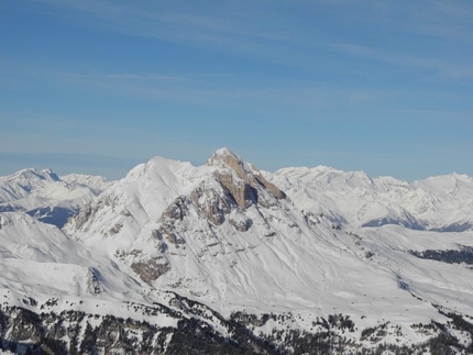
Antersasc North Gully: © Francesco Tremolada
 Planetmountain
Beauty


By
Enrico Baccanti and Francesco Tremolada, Alta Badia Guides
Ascent height difference
950m
Descent height difference
950m
Height
2471m
Difficulty
ALP: F, SKI: 4.1, Exp: E2
Time
4-5 h
Descent exposition
S + N
Departure
Longiarù in Val Badia
A great skiable north facing couloir, you traverse its south face uphill (val d’Antersass). This is not an “extreme” descent, but you need to have good ski control as well as ski mountaineering experience.
Access
Longiarù in Val Badia is the starting point. Longiarù is reached from San Martino in Badia, which can be easily reached by turning onto the road (244) which joins Brunico to the villages in Alta Badia. Once you have crossed the town of Longiarù follow the road which climbs up the valley with the same name to the evident car park (roughly 1536 metres). Itinerary
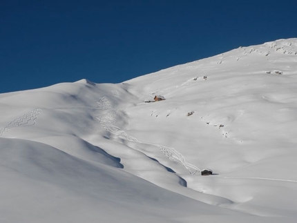
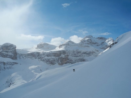
Follow the torrent’s bed and descend towards valley to reach the road which climbs up to Passo Juel (marked n°9). You can follow this road, or better, follow the meadows on its left joining up with it only further on (roughly at an altitude of 1600 m). You will have to leave it and turn right onto a summer path (marked n°9) which climbs straight up through the woods. Further up turn onto another road which you follow heading into the valley. After a nice flat area (cattle gate), climb up a steeper section along open terrain (rarely is it worth keeping up high on the right along the summer path) and you enter the upper part of the valley on the right, which seems shut off on all of its sides by the surrounding rock faces. Once you reach a characteristic and isolated tree (up to this point the ascent is the same as itinerary Cima Puez Est), detour to the right climbing up the slopes diagonally between the rock bands towards the summit of Antersas 2471 m and along a ridge continue towards Piz Somplunt 2738 m, till you reach the start of the couloir. The best starting point is not the first and most evident saddle but the one just above, which is more skiable, where the couloir can be seen entirely. Descent
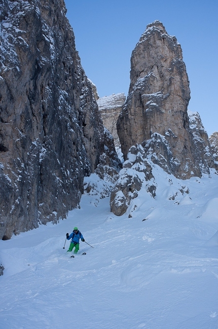
Once over the cornice, which can often be found at the entrance, ski down the first steep part and a bottleneck section which allows you to enter the real couloir. Continue down sustained terrain, which becomes wider and more skiable, till you come out onto the large slopes below. Continue the descent on snow which is almost always powdery, heading into the woods where you follow the path’s tracks on the right till you reach the forestry road (marked n°3, always tracked) which goes down directly to the car park. Gear
Crampons and ice axe (a rope is recommended for the start of the couloir in case the cornice is present). Notes
The couloir can offer hard snow after periods of north wind, if this is the case it is possible to return along the uphill itinerary. Other possibilities: The nearby couloirs Crep de le Dodesc or Piz Somplunt 2738m. Maps/Bibliography
Longiarù in Val Badia is the starting point. Longiarù is reached from San Martino in Badia, which can be easily reached by turning onto the road (244) which joins Brunico to the villages in Alta Badia. Once you have crossed the town of Longiarù follow the road which climbs up the valley with the same name to the evident car park (roughly 1536 metres). Itinerary
Follow the torrent’s bed and descend towards valley to reach the road which climbs up to Passo Juel (marked n°9). You can follow this road, or better, follow the meadows on its left joining up with it only further on (roughly at an altitude of 1600 m). You will have to leave it and turn right onto a summer path (marked n°9) which climbs straight up through the woods. Further up turn onto another road which you follow heading into the valley. After a nice flat area (cattle gate), climb up a steeper section along open terrain (rarely is it worth keeping up high on the right along the summer path) and you enter the upper part of the valley on the right, which seems shut off on all of its sides by the surrounding rock faces. Once you reach a characteristic and isolated tree (up to this point the ascent is the same as itinerary Cima Puez Est), detour to the right climbing up the slopes diagonally between the rock bands towards the summit of Antersas 2471 m and along a ridge continue towards Piz Somplunt 2738 m, till you reach the start of the couloir. The best starting point is not the first and most evident saddle but the one just above, which is more skiable, where the couloir can be seen entirely. Descent
Once over the cornice, which can often be found at the entrance, ski down the first steep part and a bottleneck section which allows you to enter the real couloir. Continue down sustained terrain, which becomes wider and more skiable, till you come out onto the large slopes below. Continue the descent on snow which is almost always powdery, heading into the woods where you follow the path’s tracks on the right till you reach the forestry road (marked n°3, always tracked) which goes down directly to the car park. Gear
Crampons and ice axe (a rope is recommended for the start of the couloir in case the cornice is present). Notes
The couloir can offer hard snow after periods of north wind, if this is the case it is possible to return along the uphill itinerary. Other possibilities: The nearby couloirs Crep de le Dodesc or Piz Somplunt 2738m. Maps/Bibliography


 See all photos
 Comments
No comments yet...
Beauty
By
Enrico Baccanti and Francesco Tremolada, Alta Badia Guides
Ascent height difference
950m
Descent height difference
950m
Height
2471m
Difficulty
ALP: F, SKI: 4.1, Exp: E2
Time
4-5 h
Descent exposition
S + N
Departure
Longiarù in Val Badia
Routes in the same mountain group
Related news
07/03/2013 - Snow Ski-skimountaineering
Dolomites ski mountaineering: the Puez Odle group Four ski mountaineering routes in the Puez Odle group of the Dolomites presented by Enrico Baccanti and Francesco Tremolada, Alta Badia Guides: Antersasc North Gully, Crep da le Dodesc, Munt...