Längentaler Weisser Kogel

 Copia link
 Roberto Iacopelli, Mountain Guide. Taken from the book 'Scialpinismo in Tirolo' Ed. Versante Sud


 1 / 4
1 / 4
Längentaler Weisser Kogel
 Planetmountain
Beauty


By
Roberto Iacopelli, Mountain Guide. Taken from the book 'Scialpinismo in Tirolo' Ed. Versante Sud
Ascent height difference
1583m
Descent height difference
1583m
Height
3217m
Difficulty
Easy
Time
5 - 6 hours
Ascent exposition
N/E N
Descent exposition
N/E N
Route

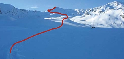
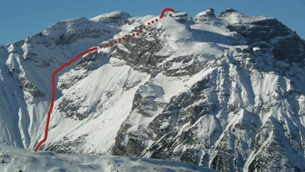
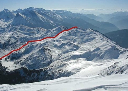
This is definitely the most classic trip in the area of the Westfalenhaus refuge. As soon as the conditions allow you to rise above 3000 metres of altitude, a track will appear along the Langental which will lead you to this summit loved by Tyrolean skiers. Throughout the whole ascent, which has a remarkable length as well as a discreet vertical height gain, winds along a single valley line which progressively climbs up till it enters the glacier of the same name to rise up only in the last hundred metres before the summit. This morphological characteristic gives it a relatively low exposure to steep slopes, therefore as soon as conditions allow it is very frequented. Even if it appears well tracked it is always wise to be critical in evaluating the right moment and not let other people’s choices drag you along. Remember, with due respect, that it is a three thousand metre peak.
Access
From Innsbruck reach Kematen (10km to the west of Innsbruck), then drive up the valley to Gries im Sellrain and turn off left for Lüsens. Itinerary
From Alpengasthof Lüsens’s paying car park go up the valley road till you reach the plains of Fernerboden. Once at the Fernerboden plains, these turn right finishing at the house of Jugendheim (approx. 1750 m.). Ascend from there directly, keeping to the bottom of the valley, first through woods and then along progressively open terrain till you reach the Längentalalm farm house. Continue along the bottom of the valley passing under the Westfalenhaus and then still ahead, but always along the line of the valley, through different troughs and basins till you reach the foot of the glacier. Go along a logical itinerary turning finally to the right in the direction of the steep final ramp. About twenty metres under the summit leave your skis to climb up easy rocks to the summit. If you stay overnight at the Westfalenhaus refuge, in the morning when you set off, it is worth following a track along the slope which enters the valley to avoid loss of elevation. When conditions are not exactly spring-like this track tends to descend directly to the bottom of the valley moving away from the slope’s steep gradient. Descent
Along the ascent route. Be careful not to take the direct descent to the glacier, even if covered it is always full of large crevasses. Maps/Bibliography
Scialpinismo in Tirolo. Le più belle gite tra Innsbruck e il Brennero by Roberto Iacopelli, Versante Sud. In Italian, German and English
 Comments
No comments yet...
Beauty
By
Roberto Iacopelli, Mountain Guide. Taken from the book 'Scialpinismo in Tirolo' Ed. Versante Sud
Ascent height difference
1583m
Descent height difference
1583m
Height
3217m
Difficulty
Easy
Time
5 - 6 hours
Ascent exposition
N/E N
Descent exposition
N/E N
Route
Routes in the same mountain group