Obernberger Tribulaun

 Copia link
 Roberto Iacopelli, Mountain Guide. Taken from the book 'Scialpinismo in Tirolo' Ed. Versante Sud


 1 / 4
1 / 4
Obernberger Tribulaun
 Planetmountain
Beauty


By
Roberto Iacopelli, Mountain Guide. Taken from the book 'Scialpinismo in Tirolo' Ed. Versante Sud
Ascent height difference
1341m
Descent height difference
1341m
Height
2780m
Difficulty
Very difficult
Time
3 - 5 hours
Ascent exposition
E, S
Descent exposition
E, S
Route
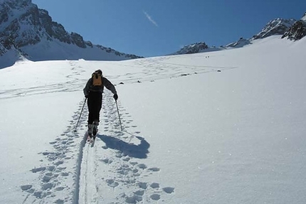
Tribulaun of Obernberg is one of the pearls in this area. You can look on dozens of Austrian ski mountaineering guide books but there will be no trace of a report of this itinerary. Nonetheless, it is well known locally and occasionally frequented. It is a perfect ski mountaineering ascent! You ski amongst steep rock faces and slopes and with the right snow pack cover you reach the summit on skis. Obviously it is an ascent which does not lack effort and long and endless slopes, without ever being exposed to dangerous rock ledges. Not for this reason should this itinerary be underestimated since it offers a special characteristic which makes it unique of its kind. With this type of ascent you always have to deal with steep slopes. 40 and 45 degree gradients are common but often limited to more or less short sections. Here the first large slope is an open couloir 700 metres of vertical height of which 600 are a constant gradient of 35 degrees or more. It is rare to find such a long slope continuously regular at such an inclination, it is definitely something to experience. Tackle this itinerary only with the right conditions of firn and with an early wake up call since the slope aspect is eastern and southern.
Access
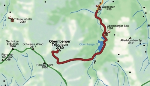
From Innsbruck drive north towards Italy, exit the motorway at Matrei and reach Gries am Brenner, then drive up the entire Obernbergtal valley. Itinerary
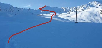
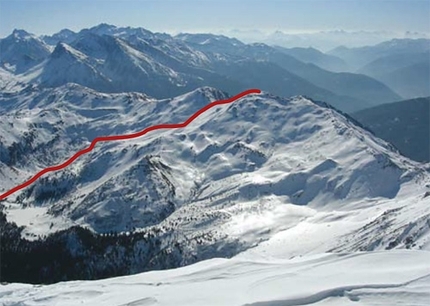
From the car park (with a parking metre) at the end of Obernbergtal (Gasthof Waldesruh) ascend to See passing close to the refuge carrying the same name. Follow the lake along a road to the orographic right (left if you ascend) till you reach the opposite edge near a forestry house. Follow the road which climbs the valley and shortly you will see the first, large section of the ascent which climbs up the open couloir. You can directly reach the base, or if you prefer to avoid the thick dwarf pines you can make a longer detour uphill. From the base to the exit of this constant 700 metres slope, proceed with kick turns making the most of the slope’s width. Where the slope ends a valley develops towards the right into the heart of the Tribulaun massif. Follow this valley to its centre overcoming two steep vertical rises consequently accessing a saddle, from here along a wide ridge you easily reach the summit. If the ridge is wind-swept, roughly one hundred metres must be climbed on foot. You may also choose to exit to the left at the first vertical rise of this hidden valley, by climbing ledges and slopes towards the summits of Nördlicher Rosslauf as well as Schwarze Wand. I shall leave it to those who follow this itinerary to verify this information which I heard about unofficially. Descent
Strictly down the ascent route.
Gear
Normal ski mountaineering equipment Maps/Bibliography
From Innsbruck drive north towards Italy, exit the motorway at Matrei and reach Gries am Brenner, then drive up the entire Obernbergtal valley. Itinerary
From the car park (with a parking metre) at the end of Obernbergtal (Gasthof Waldesruh) ascend to See passing close to the refuge carrying the same name. Follow the lake along a road to the orographic right (left if you ascend) till you reach the opposite edge near a forestry house. Follow the road which climbs the valley and shortly you will see the first, large section of the ascent which climbs up the open couloir. You can directly reach the base, or if you prefer to avoid the thick dwarf pines you can make a longer detour uphill. From the base to the exit of this constant 700 metres slope, proceed with kick turns making the most of the slope’s width. Where the slope ends a valley develops towards the right into the heart of the Tribulaun massif. Follow this valley to its centre overcoming two steep vertical rises consequently accessing a saddle, from here along a wide ridge you easily reach the summit. If the ridge is wind-swept, roughly one hundred metres must be climbed on foot. You may also choose to exit to the left at the first vertical rise of this hidden valley, by climbing ledges and slopes towards the summits of Nördlicher Rosslauf as well as Schwarze Wand. I shall leave it to those who follow this itinerary to verify this information which I heard about unofficially. Descent
Strictly down the ascent route.
Gear
Normal ski mountaineering equipment Maps/Bibliography
Scialpinismo in Tirolo. Le più belle gite tra Innsbruck e il Brennero by Roberto Iacopelli, Versante Sud. In Italian, German and English
Kompass Wanderkarte Nr. 36 Innsbruck/Brenner 1.50.000
AV-Karte Nr.31/3 Schitouren Brennerberge 1:50.000
 Comments
No comments yet...
Beauty
By
Roberto Iacopelli, Mountain Guide. Taken from the book 'Scialpinismo in Tirolo' Ed. Versante Sud
Ascent height difference
1341m
Descent height difference
1341m
Height
2780m
Difficulty
Very difficult
Time
3 - 5 hours
Ascent exposition
E, S
Descent exposition
E, S
Route
Routes in the same mountain group