Col du Génépi

 Copia link
 PlanetMountain.com


 1 / 2
1 / 2
Col du Génépi
 Planetmountain
Beauty


By
PlanetMountain.com
Descent height difference
Descend about 1550m
Difficulty
Difficult
Descent exposition
NE
Period
February to April
Route
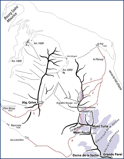
This itinerary starts from the Col de Génépi, from where the Aiguille Rouges is reached before skiing down the entire NE face of this mountain. Even though the starting point is lower than those of the other itineraries described here, the descent never the less is over 1500m long. The slopes are never too steep, and the angle remains constant throughout. Numerous variations are possible, including the option of joining up with the itineraries described previously.
Getting there
Bourg Saint Maurice is the ideal village to be based in since the stations of Les Arcs 1600, 1800 and 2000 can be easily reached either by car or cable car. To get there from Italy, drive through the Mt. Blanc tunnel and follow the signs, via Megève, to Albertville.
Continue southwards to Moutier and then drive up the Isérè valley to Bourg St. Maurice. Access
From Les Arcs 2000 take the cable car to the Aig. Rouges.
Itinerary
From the summit begin by skiing down the Villaroger piste. After an initial steep section the piste bears rightwards under the lee of the Aig. Rouges crest. Continue past the end of the Varet glacier and then leave the piste and traverse rightwards to reach the Col du Génépi. The Aig. Rouges' NE facing slopes, which clearly dominate the valley, have now been reached. There are numerous different options at this point. It is either possible to ski down rightwards from the Col and then continue directly down the final part of the Gran Col itinerary (no.3 on the map). This option, at the end, joins up with the other itineraries described previously. The itinerary is obvious, and since the slope never steepens too much this descent is a real joy!
Alternatively, it is possible to descend from the Col du Génépi and then traverse leftwards. After the first slope has been skied down (it is possible to continue down the Grades Pentes from here) keep on traversing leftwards without losing height to reach the Come des Lanchettes Descent
Ideal slopes, never too steep, but numerous gullies are skied down which, at times, are slightly exposed. Consider carefully the snow conditions in the upper part of the descent, especially after heavy snow falls or extended periods of strong wind. Gear
Rope and ice axe Notes
For further information contact:
Tourist Office 79 41 55 45
Mountain Guides 79 07 71 19
 Comments
No comments yet...
Beauty
By
PlanetMountain.com
Descent height difference
Descend about 1550m
Difficulty
Difficult
Descent exposition
NE
Period
February to April
Route
Routes in the same mountain group