Via Ferrata Passo Santner - Passo Santner

 Copia link
 Planetmountain.com


 1 / 4
1 / 4
Via Ferrata Passo Santner
 Planetmountain
Beauty


By
Planetmountain.com
Orientation
West
Ascent height difference
400m
Ferrata height difference
300m
Height
2741m
Difficulty
Medium
Time
3 hours
Period
From July to September
Popularity
High
Route
The Ferrata del Santner, situated on Catinaccio’s impressive west face, seems to have been made specifically to extenuate the beauty and very particular nature of the entire Dolomites massif. It follows a natural line diagonally leftwards and, leading relatively easily into the heart of King Laurin’s kingdom, is quite simply unforgettable. One of the most famous rock formations in the Dolomites meets the eye at the gateway to the Gartl valley: the mythical Torri del Vaiolet. The Ferrata Passo Santner is without a doubt one of the most beautiful and famous round-trips in the Dolomites.
Getting there
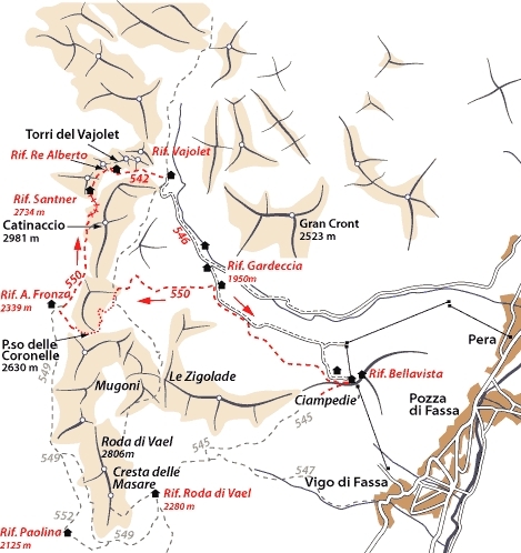
From Pozza di Fassa drive to Passo Costalunga and continue on right at the fork for the Laurin chairlift at M.ga Frommer. Take this to Rif. Fronza alle Coronelle. From Carezza take the chairlift to Rif. Paolina and continue on path no. 552-549 to Rif. Fronza.
From Vigo di Fassa take the cable car Ciampediè to Rifugio Ciampediè and then continue on paths no. 549 and 552 to Rif. Fronza. Access
From Rif. Fronza take path no. 550 up polished rocks quickly to the fork. Turn off left onto path no. 542 to cross Catinaccio’s SW face. The start of the ferrata proper is located on a scree terrace. Itinerary
From the scree terrace follow the ferrate across ladders, pegs and cables up north through gullys and across minor saddles. The path twists and turns in search of the easiest line through this rock maze to reach the highest col at 2680m. Cross this and descend carefully into a gully which often remains covered in snow. Climb up the opposite flank on the gully’s left-hand side to reach Passo Santner, 2760m, just a few minutes walk away from Rifugio Santner and the Via Normale climbing routes to the Catinaccio peaks. The panorama westwards onto the green Alto Adige deep below is stupendous. Descent
From Passo Santner follow path no. 542 down into the Gartl and the monumental Tre Torri del Vajolet. Reach Rifugio Re Alberto (2700m) and the lake at the foot of these famous towers, to continue through the large basin on path no. 542 through this massif, polished by the thousands of footsteps to the famous refuges Vajolet and Preuss (2243m). Proceed towards the Gardeccia basin to then follow signs right (no. 541). This path traverses beneath the Catinaccio’s east face to the fork and path no. 550, which leads steeply up to and over Passo delle Coronelle (2630m) to then return to Rif. Fronza. Alternatively, for those wishing to return to Rif. Ciampediè and Vigo di Fassa, follow path no. 546 from Rif. Vajolet to Rifugio Gardeccia and then continue on path no. 540 to climb up to Rifugio Ciampediè. Gear
Normal via ferrata kit. Maps/Bibliography
Via Ferratas of the Italian Dolomites: Vol 1 by John Smith and Graham Fletcher Cicerone Press 2002 Difficulty
Not particularly difficult, well-equipped ferrata. Take care when crossing the final gully before climbing up to Passo Santner, as this is often covered in hard-packed snow.

 Comments
21/01/2005 Marzia
Ho fatto questa ferrata verso la metà di agosto ma non ho incontrato molta fila!Mi è piaciuta molto per il paesaggio e sono daccordo sul fatto che non sia particolarmente impegnativa, adatta anche a chi non ha un buon allenamento alle spalle!
11/09/2004 Federico Paronitti
Una tra le più belle escursioni che abbia mai fatto; la ferrata come già detto e ridetto da tutti è facile e abbastanza corta, ci sono dei bei tratti senza assicurazione (attenzione); quando sono passato io, sul canalone prima della parete a sinistra finale era rimasta solamente una piccola lingua di ghiaccio, per cui consiglio vivamente il mese di settembre per affrontare questo percorso, anche per la minor affluenza di persone. Dal passo si gode di un magnifico panorama. Facile discesa per i rifugi Vajolet e Preuss, anche se in questo tratto ho trovato veramente molte persone che salivano (code). In fine la faticosa e lunga salita al passo delle Coronelle e la impegnativa discesa a valle su terreno friabile. Consiglio di partire presto e di godersi il panorama lungo tutto il sentiero, ne vale la pena.
23/08/2004 Andrea Governatori
Bella escursione affrontata dal rifugio Fronza in tarda mattinata causa tempo incerto.La prima parte del sentiero non è facilissima in quanto "non attrezzata".Abbastanza agevole la parte della ferrata,grandioso il panorama dal passo Satner.Molto frequentato il cammino di rientro,conviene tenersi inquota verso il passo delle Coronelle se non si ama la folla.
21/05/2004 celio franchi
ferrata semplice, senza grosse difficoltà. Attenzione alla NEVE, a inizio stazione - consiglio una piccozza, giusto per non rischiare. Molto più divertente e tecnicamente più impegnativa la ferrata della RODA DI VAEL che in questo sito non viene presa in considerazione. Consiglio pernottamento al rifugio PAOLINA ... il gestore (Herman) è veramente simpatico e i prezzi sono abbastanza abbosrtdabili. salita in seggiovia al rifugio Paolina con sconto ai soci CAI
Beauty
By
Planetmountain.com
Orientation
West
Ascent height difference
400m
Ferrata height difference
300m
Height
2741m
Difficulty
Medium
Time
3 hours
Period
From July to September
Popularity
High
Route
Routes in the same mountain group