Grubenkopf

 Copia link
 by Roberto Iacopelli, Mountain Guide. Taken from the book 'Scialpinismo in Tirolo' Ed. Versante Sud


 1 / 2
1 / 2
Grubenkopf
 Planetmountain
Beauty


By
by Roberto Iacopelli, Mountain Guide. Taken from the book 'Scialpinismo in Tirolo' Ed. Versante Sud
Ascent height difference
898m
Descent height difference
898m
Height
2337m
Difficulty
Easy
Time
2 - 3 hours
Ascent exposition
N
Descent exposition
N
Route
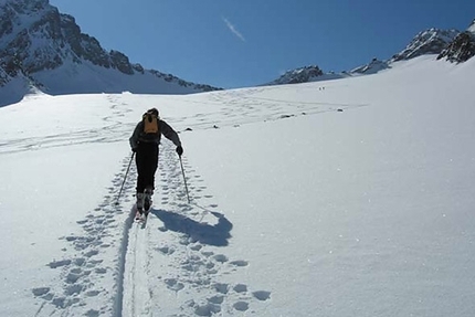
This is definitely the most frequented winter trip in the upper Obernbergtal. Constantly tracked in all conditions and in all weather it resembles a ski mountaineering motorway. So much attention is definitely deserved as it is a short but great ascent in all senses. It varies in its itinerary both for the sections in the woods as well as on open slopes and there is no time to get bored while ascending and before you know it you reach the summit. The descent, as well as being beautiful, is also varied and is a great ski. What more can you ask? The Gasthof Obernberger See is very characteristic, and when open, is worth a stop during the descent. I think I have listed all the positive points of this itinerary which is ideal during short, cold winter days.
Access
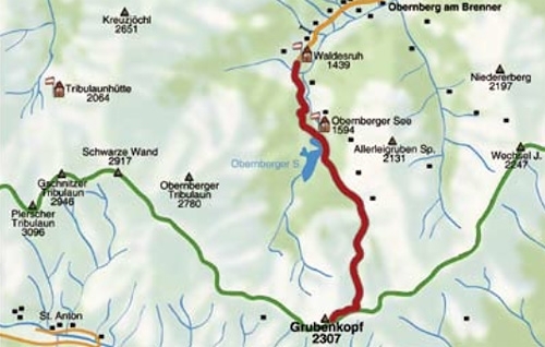
From Innsbruck drive north towards Italy, exit the motorway at Matrei and reach Gries am Brenner, then drive up the entire Obernbergtal valley. Itinerary
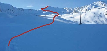
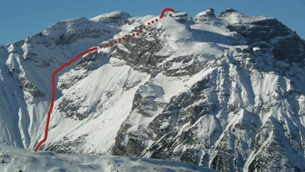
Go up the entire valley of Obernbergtal till you reach the end of the road at the level of the large paying car park. Do not stop at the first free parking spaces but move on to find a vacant spot. From the car park, southern area, the road for Gasthof Obernberger See sets off. This is a very busy sledge run, therefore it is best to keep well out of the way, then go up tracks which follow the meadows to the left and bring you to Oberrainsalm, more directly to Obernberger See. Follow the lake along the road to the left and shortly after the chapel of Maria am See (look at map of area) go towards the junction on the left which takes you to the summer trail for Sandjöchl. Follow it only for a section and then after a flat clearing, climb to the right in the direction of Grubenjoch. Once you reach the secondary pass the rest of the ascent should be on the left of the wide ridge which is often cropped by the wind. Descent
Along the ascent itinerary with variations. Watch our for snow conditions. This is a trip which is undertaken when you cannot go to other areas. There is therefore no point in choosing this itinerary if there is avalanche danger as you will find yourself on dangerous slopes anyway. Gear
Normal ski mountaineering equipment Maps/Bibliography
From Innsbruck drive north towards Italy, exit the motorway at Matrei and reach Gries am Brenner, then drive up the entire Obernbergtal valley. Itinerary
Go up the entire valley of Obernbergtal till you reach the end of the road at the level of the large paying car park. Do not stop at the first free parking spaces but move on to find a vacant spot. From the car park, southern area, the road for Gasthof Obernberger See sets off. This is a very busy sledge run, therefore it is best to keep well out of the way, then go up tracks which follow the meadows to the left and bring you to Oberrainsalm, more directly to Obernberger See. Follow the lake along the road to the left and shortly after the chapel of Maria am See (look at map of area) go towards the junction on the left which takes you to the summer trail for Sandjöchl. Follow it only for a section and then after a flat clearing, climb to the right in the direction of Grubenjoch. Once you reach the secondary pass the rest of the ascent should be on the left of the wide ridge which is often cropped by the wind. Descent
Along the ascent itinerary with variations. Watch our for snow conditions. This is a trip which is undertaken when you cannot go to other areas. There is therefore no point in choosing this itinerary if there is avalanche danger as you will find yourself on dangerous slopes anyway. Gear
Normal ski mountaineering equipment Maps/Bibliography
Scialpinismo in Tirolo. Le più belle gite tra Innsbruck e il Brennero by Roberto Iacopelli, Versante Sud. In Italian, German and English
Kompass Wanderkarte Nr. 36 Innsbruck/Brenner 1.50.000
AV-Karte Nr.31/3 Schitouren Brennerberge 1:50.000
 Comments
No comments yet...
Beauty
By
by Roberto Iacopelli, Mountain Guide. Taken from the book 'Scialpinismo in Tirolo' Ed. Versante Sud
Ascent height difference
898m
Descent height difference
898m
Height
2337m
Difficulty
Easy
Time
2 - 3 hours
Ascent exposition
N
Descent exposition
N
Route
Routes in the same mountain group