Cassin Route - Walker Spur - Grandes Jorasses

 Copia link
 Enrico Bonino, Mountain Guide


 1 / 24
Cassin Route - Walker Spur: Photo Enrico Bonino
 Planetmountain
Beauty

First ascent
Riccardo Cassin, Luigi Esposito, Ugo Tizzoni, 4-6 August 1938
By
Enrico Bonino, Mountain Guide
Orientation
NE - NW
Length
1200m
Height
3000m - 4200m
Difficulty
6°/A0
Route

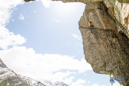
'The rock face of all rock faces', 'the route of all routes': the Cassin route up the Walker Spur on the North Face of the Grandes Jorasses represents a dream for all alpinists. The route is highly demanding and due to its length it should only be climbed when the mountain is in excellent condition and you are perfectly fit and acclimatised.
Getting there
Reach Chamonix, park the car at the Montenvers station and then take the track and pinion train to the upper station from where the path leads off to Refuge Lechaux Access
To reach Refuge Lechaux: descend onto the Mer de Glace glacier via the ladders abd cables, cross the glacial moraine left and end the basin of the North Face of the Grandes Jorasses to reach the refuge, perched high on the left. Calculate circa 2.5 hours from the Montenvers mountain station. From Refuge Lechaux
continue ascending as best possible the Lechaux glacier to reach the base of the spur which descends from Pointe Walker. Itinerary
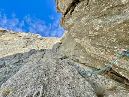
The Bergschrund which grants access to the first slope was too wide (19-20/07/2010) which meant we started on the rocks lower down. A 5b pitch led to easier ground which enabled us to cross the slope and reach the start of the difficulties.
Route finding on the first third of the route isn't that straightforward and reaching the base of the 30m corner at first light is paramount otherwise it's extremely easy to climb off route. The corner on the left, also known as The Rebuffat Corner, has some in-situ pegs. Standing beneath the base of this (and many other) pitches you'll find it hard to believe that Cassin made his way up here in 1938... but this is exactly what he did.
The first section of the route follows a line rightwards towards the MacIntyre gully. The 75m high corner is hidden behind the arête, so don't hesitate searching for it towards the gully. Three 20/30m pitches of stupendous climbing up the open-book shaped corner lead to the top - there is plenty plenty of in-situ gear along the corner.
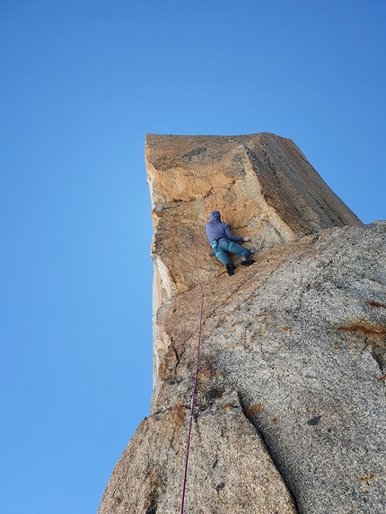
From here continue upwards, following a fairly direct line, to reach the decidedly steep grey and black slabs. A belay can be mad out to the right, at the base of small overhang. Do not climb to this direct byt instead continue upwards via the leaning gully to reach a ledge which traverses rightwards to a small arete. From here abseil 10m to reach the base of the overhang.
Climb over this up loose rock and continue ascending diagonally right. The following pitches climb up and above the grey tower. Some easy but nevertheless never banal pitches on the crest lead to the triangular shaped snow field. This can be avoided by climbing two harder rock pitches which lead directly to the red chimneys. We climbed the original route and ascended to the top of the snow field, then traverese right to reach the red chimneys.
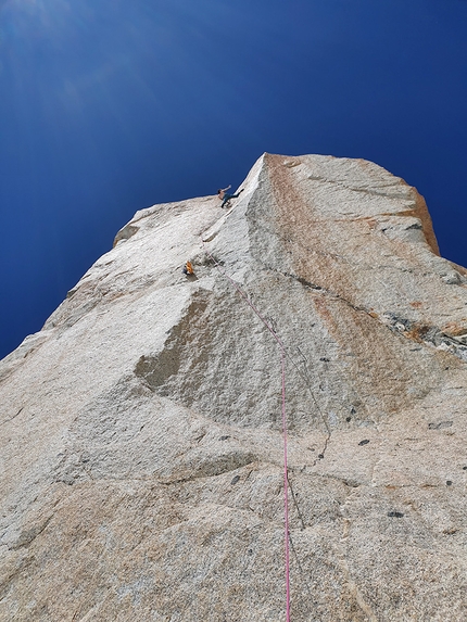
This obvious gully is the most dangerous section of the route since the rock quality is terrible and you are directly exposed to rock fall. A fixed rope is in-situ on the second pitch and although useful, the sheath is completely trashed. When the chimney becomes deep and steep traverse right (do not climb past the overhang with the peg but continue for a few meters then climb right into a corner). A final short headwall leads to ledge and then a gully which leads past the hardest difficulties. Another 6/7 pitches of Grade III/IV climbing lead to the summit. Descent
Seeing how the serac on the normal route is evolving, a descent down Rocher Whymper is highly recommended. This is reached by descending the gully for circa 100m wedged between the rocher and the serac and which leads to the spur. Descend to reach the abseil which lead to the right flank (descending) and which lead to the gully which separates the Rochers from the Rocher du Reposoir. The glacier is tormented and is crossed as best possible. Downclimb the Reposoir, keeping on the line of the crest and following its weak points, to reach the glacier which, in turn, leads to Rifugio Boccalatte. Gear
A full set of camming devices, Camalot 0.3 - 2, a selection of small and mid-size nuts, 12 quickdraws, hammer and pegs, slings, two 50m ropes. Ice axe, crampons and helmet. Notes
Long and extremely demanding route which should only be climbed when the mountain is in excellent condition and you are perfectly fit and acclimatised. We climbed the route almost exclusively with climbing shoes in a single day, with a bivvy at Rochers Whymper to wait for the snow to refreeze. There are not many comfortable ledges to bivvy along the route.
Reach Chamonix, park the car at the Montenvers station and then take the track and pinion train to the upper station from where the path leads off to Refuge Lechaux Access
To reach Refuge Lechaux: descend onto the Mer de Glace glacier via the ladders abd cables, cross the glacial moraine left and end the basin of the North Face of the Grandes Jorasses to reach the refuge, perched high on the left. Calculate circa 2.5 hours from the Montenvers mountain station. From Refuge Lechaux
continue ascending as best possible the Lechaux glacier to reach the base of the spur which descends from Pointe Walker. Itinerary
The Bergschrund which grants access to the first slope was too wide (19-20/07/2010) which meant we started on the rocks lower down. A 5b pitch led to easier ground which enabled us to cross the slope and reach the start of the difficulties.
Route finding on the first third of the route isn't that straightforward and reaching the base of the 30m corner at first light is paramount otherwise it's extremely easy to climb off route. The corner on the left, also known as The Rebuffat Corner, has some in-situ pegs. Standing beneath the base of this (and many other) pitches you'll find it hard to believe that Cassin made his way up here in 1938... but this is exactly what he did.
The first section of the route follows a line rightwards towards the MacIntyre gully. The 75m high corner is hidden behind the arête, so don't hesitate searching for it towards the gully. Three 20/30m pitches of stupendous climbing up the open-book shaped corner lead to the top - there is plenty plenty of in-situ gear along the corner.
From here continue upwards, following a fairly direct line, to reach the decidedly steep grey and black slabs. A belay can be mad out to the right, at the base of small overhang. Do not climb to this direct byt instead continue upwards via the leaning gully to reach a ledge which traverses rightwards to a small arete. From here abseil 10m to reach the base of the overhang.
Climb over this up loose rock and continue ascending diagonally right. The following pitches climb up and above the grey tower. Some easy but nevertheless never banal pitches on the crest lead to the triangular shaped snow field. This can be avoided by climbing two harder rock pitches which lead directly to the red chimneys. We climbed the original route and ascended to the top of the snow field, then traverese right to reach the red chimneys.
This obvious gully is the most dangerous section of the route since the rock quality is terrible and you are directly exposed to rock fall. A fixed rope is in-situ on the second pitch and although useful, the sheath is completely trashed. When the chimney becomes deep and steep traverse right (do not climb past the overhang with the peg but continue for a few meters then climb right into a corner). A final short headwall leads to ledge and then a gully which leads past the hardest difficulties. Another 6/7 pitches of Grade III/IV climbing lead to the summit. Descent
Seeing how the serac on the normal route is evolving, a descent down Rocher Whymper is highly recommended. This is reached by descending the gully for circa 100m wedged between the rocher and the serac and which leads to the spur. Descend to reach the abseil which lead to the right flank (descending) and which lead to the gully which separates the Rochers from the Rocher du Reposoir. The glacier is tormented and is crossed as best possible. Downclimb the Reposoir, keeping on the line of the crest and following its weak points, to reach the glacier which, in turn, leads to Rifugio Boccalatte. Gear
A full set of camming devices, Camalot 0.3 - 2, a selection of small and mid-size nuts, 12 quickdraws, hammer and pegs, slings, two 50m ropes. Ice axe, crampons and helmet. Notes
Long and extremely demanding route which should only be climbed when the mountain is in excellent condition and you are perfectly fit and acclimatised. We climbed the route almost exclusively with climbing shoes in a single day, with a bivvy at Rochers Whymper to wait for the snow to refreeze. There are not many comfortable ledges to bivvy along the route.


 See all photos
 Comments
14/08/2010 Barry
Grande via, gran esperienza...un anno fa esatto ci mancava mezz'ora alla punta, dal triangolare in poi condizioni da ramponi. Grandioso il "vecchio" Cassin a sverginarla nel '38!
26/07/2010 marco conti
...solamente complimenti Enrico, è uno dei più grandi sogni/traguardo a cui un alpinista completo può ambire..Nell'estate '90 con Gianfranco Rossetto uscimmo in punta alle G.J. alle 20,00 di sera..Avevo 26 anni!Unico rammarico a 20 anni di distanza : non essere in cima con mia moglie Mirella"podina"
Beauty
First ascent
Riccardo Cassin, Luigi Esposito, Ugo Tizzoni, 4-6 August 1938
By
Enrico Bonino, Mountain Guide
Orientation
NE - NW
Length
1200m
Height
3000m - 4200m
Difficulty
6°/A0
Route
Routes in the same mountain group
Show more in Mont Blanc