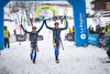
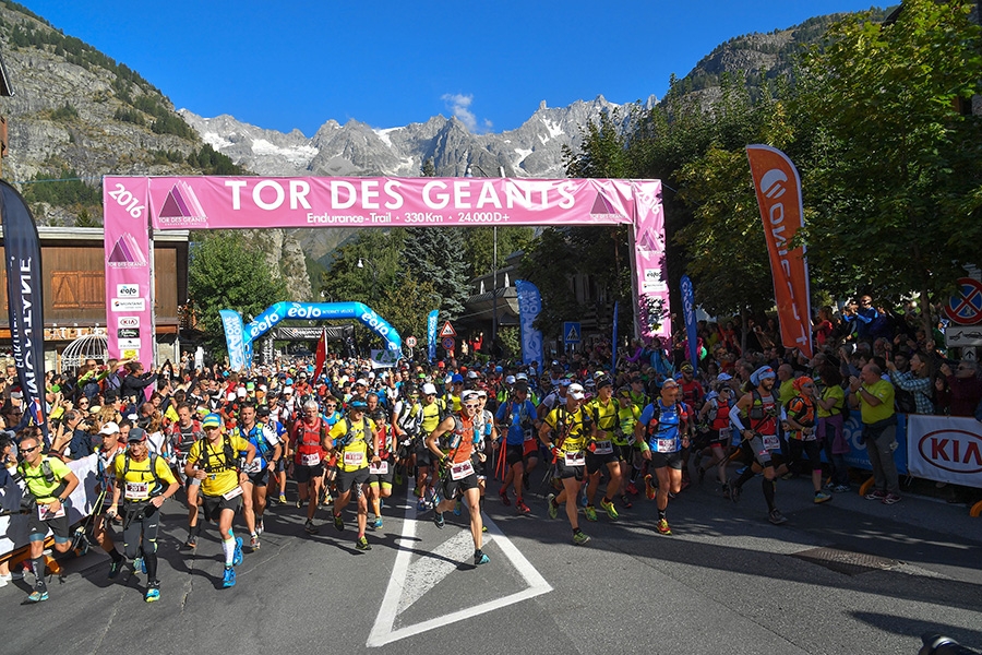
Tor des Géants, the start of the legendary race

 Copia link

 1 / 13
 Giorgio Augusto
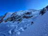
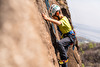
They’re off! In real time - 10:00 o’clock sharp - and in ideal weather - sun and crisp temperatures - the 770 trailers of the Tor des Géants 2016 embarked on their 330km journey. On Saturday evening they picked up the bibs at the starting ceremony at the Courmayeur Forum Sport Center of Dolonne, and on Sunday morning the start was celebrated with multitude of spectators. Fans are a fundamental part of this race start, making the contest something to remember for everyone.
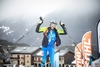
Gianluca Galeati, one to watch out for (second last year) immediately took the lead across the first mountain passes, at La Thuile after 16,6 km and at the Deffeyes Refuge, at 2.550m. At continued past both points without stoping. The first surprise withdrawal occurred at Promoud, shortly before the first life base at Valgrisenche after 50 km: Ireland’s Dan Doherty who had been trailing Galeati by a mere 8 minutes. Doherty had been forced to withdraw from the race last year, too, and before the start Galeati had confessed “perhaps Dan is the trailer I fear most”. The two “first ladies”, Silvia Trigueros Garrote and Lisa Borzoi, passed Promoud a short while later.
Galeati clung on to the lead at Col de la Crosstie 2.829 m, before the steep descent (1.000 m D-) down to Valgrisenche where he arrived at 5.35 pm, having gained a big lead over his main rivals Eric Breton from Canada and Nahuel Passerat from France.
Meanwhile, during yesterday’s opening day, it’s worth underlining the huge support of the inhabitants of Cogne. One of the directors of VDA Trailers arrived early in the morning and was greeted by a large delegation of citizens from Cogne. A lot of people and volunteers were ready to prepare the life base, at 106 km from the start, where early this morning the first runners will briefly check in. The solidarity of the people from the Aosta Valley overcomes all barriers.
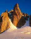
The route will run along the Alta Via 1 and Alta Via 2 of the Valle d'Aosta, with the start and finishing line in Courmayeur, and will cover a total of around 336km (200 miles), with an altitude range of 24,000 metres. The landscape at the foot of the region’s Four-Thousanders makes the route especially spectacular.
Along the route there will be a number of rest, rescue and refreshment points, as well as seven larger bases that will divide the route up into seven sectors:
Courmayeur – Valgrisenche: 50 km 4747 D+
Valgrisenche – Cogne: 58 km 5082 D+
Cogne – Donnas: 45 km 2698 D+
Donnas – Gressoney St Jean: 54 km 6086 D+
Gressoney St Jean – Valtournenche: 33 km 3187 D+
Valtournenche – Ollomont: 48 km 4904 D+
Ollomont – Courmayeur: 50 km 4210 D+
Rescue points: checkpoints where runners can call for rescue and receive help. Where necessary, mobile bivouacs may be set up to provide shelter for runners and volunteers in the event of unfavourable weather conditions or other difficulties.
Refreshment points: where food and drink will be supplied. The location and organisation of these points has been studied in such a way as to facilitate assistance and access to supplies.
Bases: where assistance and medical care will be provided by doctors and nurses for all those who intend to continue with the race, with emergency treatment guaranteed. Rest area will be set aside within the bases, and these will become intermediate finishing lines for runners who do not intend to complete the race.
Safety and transport: Each rescue, refreshment and water point is also a checkpoint for runners, whose times are recorded.
A radio link will be set up between the various checkpoints and the operations centre in Courmayeur, in order to monitor runners as they pass through. A safety runner service will be available at the end of the race. From every refreshment, rescue and first aid point a service will operate to take runners back to the nearest base and from there to the centre of Courmayeur.
Timing and checks: Each runner will be provided with a wristband with an ID chip, which will be read by an aerial as they pass through each checkpoint. This information is then sent via internet to the central server to allow the progress of the race to be monitored. The times may be viewed on the race website so the progress of the runners can be viewed during the race.


 See all photos
| Expo.Planetmountain | |
| Ferrino | |
| Grivel | |
| www | |
| www.tordesgeants.it | |